From the PO.DAAC Cookbook, to access the GitHub version of the notebook, follow this link.
Note: This notebook uses Version C (2.0) of SWOT data that was available at the time of this notebook’s development. The most recent data is now available as Version D for SWOT collections.The last Version C measurement will be until May 3rd, 2025. The first Version D measurement starts on May 5th, 2025.
Download and Access L2 SWOT Oceanography Data
Summary
This notebook will show direct download of PO.DAAC archived products onto your local machine. In this demo, we will showcase the usage of SWOT Level 2 Low Rate products from Version C of the data, aka 2.0:
SWOT Level 2 KaRIn Low Rate Sea Surface Height Data Product - shortname SWOT_L2_LR_SSH_2.0
SWOT Level 2 Nadir Altimeter Interim Geophysical Data Record with Waveforms - SSHA Version C - shortname SWOT_L2_NALT_IGDR_SSHA_2.0
This is a subcollection of the parent collection: SWOT_L2_NALT_IGDR_2.0
SWOT Level 2 Radiometer Data Products - overview of all
We will download the data and load a time series made of multiple netCDF files into a single xarray dataset.
Requirements
Local compute environment e.g. laptop, server: this tutorial can be run on your local machine.
Learning Objectives
authenticate for earthaccess Python Library using your NASA Earthdata Login
access DAAC data by downloading directly into your local machine and operating on those files.
plot the first time step in the data
Import Libraries
import xarray as xrimport s3fsimport cartopy.crs as ccrsfrom matplotlib import pyplot as pltimport earthaccessfrom earthaccess import Auth, DataCollections, DataGranules, Store%matplotlib inline
Earthdata Login
An Earthdata Login account is required to access data, as well as discover restricted data, from the NASA Earthdata system. Thus, to access NASA data, you need Earthdata Login. Please visit https://urs.earthdata.nasa.gov to register and manage your Earthdata Login account. This account is free to create and only takes a moment to set up. We use earthaccess to authenticate your login credentials below.
auth = earthaccess.login()
1. SWOT Level 2 KaRIn Low Rate Sea Surface Height Data Product
Outlined below is a map of the different KaRIn Data Products we host at PO.DAAC and their sub collections, and why you may choose one over the other. For more information, see the SWOT Data User Handbook.
Once you’ve picked the dataset you want to look at, you can enter its shortname or subcollection below in the search query.
Search and Download Data!
It’s time to find our data! Below we are searching using earthaccess Python library.
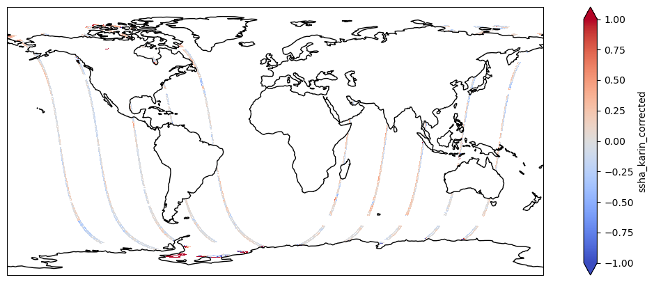
#retrieves granule from the day we wantkarin_results = earthaccess.search_data(short_name ='SWOT_L2_LR_SSH_2.0', temporal = ("2024-02-01 12:00:00", "2024-02-01 19:43:00"), granule_name ='*Expert*') # filter by files with "Expert" in file name. This collection has subcollections of 'Basic', 'Windwave', 'Unsmoothed' and 'Expert' granules.
#load downloaded data into dataset to be used for plottingds = xr.open_mfdataset("./data_downloads/SWOT_files/SWOT_L2_LR_SSH_Expert*.nc", combine='nested', concat_dim="num_lines", decode_times=False)ds
Latitude of measurement [-80,80]. Positive latitude is North latitude, negative latitude is South latitude.
Array
Chunk
Bytes
51.94 MiB
5.19 MiB
Shape
(98660, 69)
(9866, 69)
Dask graph
10 chunks in 21 graph layers
Data type
float64 numpy.ndarray
longitude
(num_lines, num_pixels)
float64
dask.array<chunksize=(9866, 69), meta=np.ndarray>
long_name :
longitude (degrees East)
standard_name :
longitude
units :
degrees_east
valid_min :
0
valid_max :
359999999
comment :
Longitude of measurement. East longitude relative to Greenwich meridian.
Array
Chunk
Bytes
51.94 MiB
5.19 MiB
Shape
(98660, 69)
(9866, 69)
Dask graph
10 chunks in 21 graph layers
Data type
float64 numpy.ndarray
latitude_nadir
(num_lines)
float64
dask.array<chunksize=(9866,), meta=np.ndarray>
long_name :
latitude of satellite nadir point
standard_name :
latitude
units :
degrees_north
quality_flag :
orbit_qual
valid_min :
-80000000
valid_max :
80000000
comment :
Geodetic latitude [-80,80] (degrees north of equator) of the satellite nadir point.
Array
Chunk
Bytes
770.78 kiB
77.08 kiB
Shape
(98660,)
(9866,)
Dask graph
10 chunks in 21 graph layers
Data type
float64 numpy.ndarray
longitude_nadir
(num_lines)
float64
dask.array<chunksize=(9866,), meta=np.ndarray>
long_name :
longitude of satellite nadir point
standard_name :
longitude
units :
degrees_east
quality_flag :
orbit_qual
valid_min :
0
valid_max :
359999999
comment :
Longitude (degrees east of Grenwich meridian) of the satellite nadir point.
Array
Chunk
Bytes
770.78 kiB
77.08 kiB
Shape
(98660,)
(9866,)
Dask graph
10 chunks in 21 graph layers
Data type
float64 numpy.ndarray
time
(num_lines)
float64
dask.array<chunksize=(9866,), meta=np.ndarray>
long_name :
time in UTC
standard_name :
time
calendar :
gregorian
tai_utc_difference :
37.0
leap_second :
0000-00-00T00:00:00Z
units :
seconds since 2000-01-01 00:00:00.0
comment :
Time of measurement in seconds in the UTC time scale since 1 Jan 2000 00:00:00 UTC. [tai_utc_difference] is the difference between TAI and UTC reference time (seconds) for the first measurement of the data set. If a leap second occurs within the data set, the attribute leap_second is set to the UTC time at which the leap second occurs.
Array
Chunk
Bytes
770.78 kiB
77.08 kiB
Shape
(98660,)
(9866,)
Dask graph
10 chunks in 21 graph layers
Data type
float64 numpy.ndarray
time_tai
(num_lines)
float64
dask.array<chunksize=(9866,), meta=np.ndarray>
long_name :
time in TAI
standard_name :
time
calendar :
gregorian
tai_utc_difference :
37.0
units :
seconds since 2000-01-01 00:00:00.0
comment :
Time of measurement in seconds in the TAI time scale since 1 Jan 2000 00:00:00 TAI. This time scale contains no leap seconds. The difference (in seconds) with time in UTC is given by the attribute [time:tai_utc_difference].
Array
Chunk
Bytes
770.78 kiB
77.08 kiB
Shape
(98660,)
(9866,)
Dask graph
10 chunks in 21 graph layers
Data type
float64 numpy.ndarray
ssh_karin
(num_lines, num_pixels)
float64
dask.array<chunksize=(9866, 69), meta=np.ndarray>
long_name :
sea surface height
standard_name :
sea surface height above reference ellipsoid
units :
m
quality_flag :
ssh_karin_qual
valid_min :
-15000000
valid_max :
150000000
comment :
Fully corrected sea surface height measured by KaRIn. The height is relative to the reference ellipsoid defined in the global attributes. This value is computed using radiometer measurements for wet troposphere effects on the KaRIn measurement (e.g., rad_wet_tropo_cor and sea_state_bias_cor).
Quality flag for the SSHA from KaRIn in the ssha_karin variable.
Array
Chunk
Bytes
51.94 MiB
5.19 MiB
Shape
(98660, 69)
(9866, 69)
Dask graph
10 chunks in 21 graph layers
Data type
float64 numpy.ndarray
ssh_karin_2
(num_lines, num_pixels)
float64
dask.array<chunksize=(9866, 69), meta=np.ndarray>
long_name :
sea surface height
standard_name :
sea surface height above reference ellipsoid
units :
m
quality_flag :
ssh_karin_2_qual
valid_min :
-15000000
valid_max :
150000000
comment :
Fully corrected sea surface height measured by KaRIn. The height is relative to the reference ellipsoid defined in the global attributes. This value is computed using model-based estimates for wet troposphere effects on the KaRIn measurement (e.g., model_wet_tropo_cor and sea_state_bias_cor_2).
Normalized radar cross section (sigma0) from KaRIn in real, linear units (not decibels). The value may be negative due to noise subtraction. The value is corrected for instrument calibration and atmospheric attenuation. Radiometer measurements provide the atmospheric attenuation (sig0_cor_atmos_rad).
Normalized radar cross section (sigma0) from KaRIn in real, linear units (not decibels). The value may be negative due to noise subtraction. The value is corrected for instrument calibration and atmospheric attenuation. A meteorological model provides the atmospheric attenuation (sig0_cor_atmos_model).
Quality flag for wind speed from KaRIn in wind_speed_karin_2 variable.
Array
Chunk
Bytes
51.94 MiB
5.19 MiB
Shape
(98660, 69)
(9866, 69)
Dask graph
10 chunks in 21 graph layers
Data type
float64 numpy.ndarray
num_pt_avg
(num_lines, num_pixels)
float32
dask.array<chunksize=(9866, 69), meta=np.ndarray>
long_name :
number of samples averaged
units :
1
valid_min :
0
valid_max :
289
comment :
Number of native unsmoothed, beam-combined KaRIn samples averaged.
Array
Chunk
Bytes
25.97 MiB
2.60 MiB
Shape
(98660, 69)
(9866, 69)
Dask graph
10 chunks in 21 graph layers
Data type
float32 numpy.ndarray
swh_wind_speed_karin_source
(num_lines, num_pixels)
float32
dask.array<chunksize=(9866, 69), meta=np.ndarray>
long_name :
source flag for significant wave height information used to compute wind speed from KaRIn
standard_name :
status_flag
flag_meanings :
nadir_altimeter karin model
flag_masks :
[1 2 4]
valid_min :
0
valid_max :
7
comment :
Bit flag that indicates the source of significant wave height information that was used to compute the wind speed estimate from KaRIn data in wind_speed_karin.
Array
Chunk
Bytes
25.97 MiB
2.60 MiB
Shape
(98660, 69)
(9866, 69)
Dask graph
10 chunks in 21 graph layers
Data type
float32 numpy.ndarray
swh_wind_speed_karin_source_2
(num_lines, num_pixels)
float32
dask.array<chunksize=(9866, 69), meta=np.ndarray>
long_name :
source flag for significant wave height information used to compute wind speed from KaRIn
standard_name :
status_flag
flag_meanings :
nadir_altimeter karin model
flag_masks :
[1 2 4]
valid_min :
0
valid_max :
7
comment :
Bit flag that indicates the source of significant wave height information that was used to compute the wind speed estimate from KaRIn data in wind_speed_karin_2.
Array
Chunk
Bytes
25.97 MiB
2.60 MiB
Shape
(98660, 69)
(9866, 69)
Dask graph
10 chunks in 21 graph layers
Data type
float32 numpy.ndarray
swh_nadir_altimeter
(num_lines, num_pixels)
float64
dask.array<chunksize=(9866, 69), meta=np.ndarray>
long_name :
significant wave height from nadir altimeter
standard_name :
sea_surface_wave_significant_height
units :
m
valid_min :
0
valid_max :
15000
comment :
Significant wave height from nadir altimeter.
Array
Chunk
Bytes
51.94 MiB
5.19 MiB
Shape
(98660, 69)
(9866, 69)
Dask graph
10 chunks in 21 graph layers
Data type
float64 numpy.ndarray
swh_model
(num_lines, num_pixels)
float64
dask.array<chunksize=(9866, 69), meta=np.ndarray>
long_name :
significant wave height from wave model
standard_name :
sea_surface_wave_significant_height
source :
European Centre for Medium-Range Weather Forecasts
Sea surface wind wave mean period from model spectral density second moment.
Array
Chunk
Bytes
51.94 MiB
5.19 MiB
Shape
(98660, 69)
(9866, 69)
Dask graph
10 chunks in 21 graph layers
Data type
float64 numpy.ndarray
wind_speed_model_u
(num_lines, num_pixels)
float64
dask.array<chunksize=(9866, 69), meta=np.ndarray>
long_name :
u component of model wind
standard_name :
eastward_wind
source :
European Centre for Medium-Range Weather Forecasts
institution :
ECMWF
units :
m/s
valid_min :
-30000
valid_max :
30000
comment :
Eastward component of the atmospheric model wind vector at 10 meters.
Array
Chunk
Bytes
51.94 MiB
5.19 MiB
Shape
(98660, 69)
(9866, 69)
Dask graph
10 chunks in 21 graph layers
Data type
float64 numpy.ndarray
wind_speed_model_v
(num_lines, num_pixels)
float64
dask.array<chunksize=(9866, 69), meta=np.ndarray>
long_name :
v component of model wind
standard_name :
northward_wind
source :
European Centre for Medium-Range Weather Forecasts
institution :
ECMWF
units :
m/s
valid_min :
-30000
valid_max :
30000
comment :
Northward component of the atmospheric model wind vector at 10 meters.
Array
Chunk
Bytes
51.94 MiB
5.19 MiB
Shape
(98660, 69)
(9866, 69)
Dask graph
10 chunks in 21 graph layers
Data type
float64 numpy.ndarray
wind_speed_rad
(num_lines, num_sides)
float64
dask.array<chunksize=(9866, 2), meta=np.ndarray>
long_name :
wind speed from radiometer
standard_name :
wind_speed
source :
Advanced Microwave Radiometer
units :
m/s
valid_min :
0
valid_max :
65000
comment :
Wind speed from radiometer measurements.
Array
Chunk
Bytes
1.51 MiB
154.16 kiB
Shape
(98660, 2)
(9866, 2)
Dask graph
10 chunks in 21 graph layers
Data type
float64 numpy.ndarray
distance_to_coast
(num_lines, num_pixels)
float64
dask.array<chunksize=(9866, 69), meta=np.ndarray>
long_name :
distance to coast
source :
MODIS/GlobCover
institution :
European Space Agency
units :
m
valid_min :
-21000
valid_max :
21000
comment :
Approximate distance to the nearest coast point along the Earth surface.
Array
Chunk
Bytes
51.94 MiB
5.19 MiB
Shape
(98660, 69)
(9866, 69)
Dask graph
10 chunks in 21 graph layers
Data type
float64 numpy.ndarray
heading_to_coast
(num_lines, num_pixels)
float64
dask.array<chunksize=(9866, 69), meta=np.ndarray>
long_name :
heading to coast
units :
degrees
valid_min :
0
valid_max :
35999
comment :
Approximate compass heading (0-360 degrees with respect to true north) to the nearest coast point.
Array
Chunk
Bytes
51.94 MiB
5.19 MiB
Shape
(98660, 69)
(9866, 69)
Dask graph
10 chunks in 21 graph layers
Data type
float64 numpy.ndarray
ancillary_surface_classification_flag
(num_lines, num_pixels)
float32
dask.array<chunksize=(9866, 69), meta=np.ndarray>
long_name :
surface classification
standard_name :
status_flag
source :
MODIS/GlobCover
institution :
European Space Agency
flag_meanings :
open_ocean land continental_water aquatic_vegetation continental_ice_snow floating_ice salted_basin
flag_values :
[0 1 2 3 4 5 6]
valid_min :
0
valid_max :
6
comment :
7-state surface type classification computed from a mask built with MODIS and GlobCover data.
Array
Chunk
Bytes
25.97 MiB
2.60 MiB
Shape
(98660, 69)
(9866, 69)
Dask graph
10 chunks in 21 graph layers
Data type
float32 numpy.ndarray
dynamic_ice_flag
(num_lines, num_pixels)
float32
dask.array<chunksize=(9866, 69), meta=np.ndarray>
long_name :
dynamic ice flag
standard_name :
status_flag
source :
EUMETSAT Ocean and Sea Ice Satellite Applications Facility
institution :
EUMETSAT
flag_meanings :
no_ice probable_ice ice no_data
flag_values :
[0 1 2 3]
valid_min :
0
valid_max :
3
comment :
Dynamic ice flag for the location of the KaRIn measurement.
Array
Chunk
Bytes
25.97 MiB
2.60 MiB
Shape
(98660, 69)
(9866, 69)
Dask graph
10 chunks in 21 graph layers
Data type
float32 numpy.ndarray
rain_flag
(num_lines, num_pixels)
float32
dask.array<chunksize=(9866, 69), meta=np.ndarray>
long_name :
rain flag
standard_name :
status_flag
flag_meanings :
no_rain probable_rain rain no_data
flag_values :
[0 1 2 3]
valid_min :
0
valid_max :
3
comment :
Flag indicates that signal is attenuated, probably from rain.
Array
Chunk
Bytes
25.97 MiB
2.60 MiB
Shape
(98660, 69)
(9866, 69)
Dask graph
10 chunks in 21 graph layers
Data type
float32 numpy.ndarray
rad_surface_type_flag
(num_lines, num_sides)
float32
dask.array<chunksize=(9866, 2), meta=np.ndarray>
long_name :
radiometer surface type flag
standard_name :
status_flag
source :
Advanced Microwave Radiometer
flag_meanings :
open_ocean coastal_ocean land
flag_values :
[0 1 2]
valid_min :
0
valid_max :
2
comment :
Flag indicating the validity and type of processing applied to generate the wet troposphere correction (rad_wet_tropo_cor). A value of 0 indicates that open ocean processing is used, a value of 1 indicates coastal processing, and a value of 2 indicates that rad_wet_tropo_cor is invalid due to land contamination.
Array
Chunk
Bytes
770.78 kiB
77.08 kiB
Shape
(98660, 2)
(9866, 2)
Dask graph
10 chunks in 21 graph layers
Data type
float32 numpy.ndarray
sc_altitude
(num_lines)
float64
dask.array<chunksize=(9866,), meta=np.ndarray>
long_name :
altitude of KMSF origin
standard_name :
height_above_reference_ellipsoid
units :
m
quality_flag :
orbit_qual
valid_min :
0
valid_max :
2000000000
comment :
Altitude of the KMSF origin.
Array
Chunk
Bytes
770.78 kiB
77.08 kiB
Shape
(98660,)
(9866,)
Dask graph
10 chunks in 21 graph layers
Data type
float64 numpy.ndarray
orbit_alt_rate
(num_lines)
float64
dask.array<chunksize=(9866,), meta=np.ndarray>
long_name :
orbital altitude rate with respect to mean sea surface
units :
m/s
valid_min :
-3500
valid_max :
3500
comment :
Orbital altitude rate with respect to the mean sea surface.
Array
Chunk
Bytes
770.78 kiB
77.08 kiB
Shape
(98660,)
(9866,)
Dask graph
10 chunks in 21 graph layers
Data type
float64 numpy.ndarray
cross_track_angle
(num_lines)
float64
dask.array<chunksize=(9866,), meta=np.ndarray>
long_name :
cross-track angle from true north
units :
degrees
valid_min :
0
valid_max :
359999999
comment :
Angle with respect to true north of the cross-track direction to the right of the spacecraft velocity vector.
Array
Chunk
Bytes
770.78 kiB
77.08 kiB
Shape
(98660,)
(9866,)
Dask graph
10 chunks in 21 graph layers
Data type
float64 numpy.ndarray
sc_roll
(num_lines)
float64
dask.array<chunksize=(9866,), meta=np.ndarray>
long_name :
roll of the spacecraft
standard_name :
platform_roll_angle
units :
degrees
quality_flag :
orbit_qual
valid_min :
-1799999
valid_max :
1800000
comment :
KMSF attitude roll angle; positive values move the +y antenna down.
KMSF attitude yaw angle relative to the nadir track. The yaw angle is a right-handed rotation about the nadir (downward) direction. A yaw value of 0 deg indicates that the KMSF +x axis is aligned with the horizontal component of the Earth-relative velocity vector. A yaw value of 180 deg indicates that the spacecraft is in a yaw-flipped state, with the KMSF -x axis aligned with the horizontal component of the Earth-relative velocity vector.
Array
Chunk
Bytes
770.78 kiB
77.08 kiB
Shape
(98660,)
(9866,)
Dask graph
10 chunks in 21 graph layers
Data type
float64 numpy.ndarray
velocity_heading
(num_lines)
float64
dask.array<chunksize=(9866,), meta=np.ndarray>
long_name :
heading of the spacecraft Earth-relative velocity vector
units :
degrees
quality_flag :
orbit_qual
valid_min :
0
valid_max :
359999999
comment :
Angle with respect to true north of the horizontal component of the spacecraft Earth-relative velocity vector. A value of 90 deg indicates that the spacecraft velocity vector pointed due east. Values between 0 and 90 deg indicate that the velocity vector has a northward component, and values between 90 and 180 deg indicate that the velocity vector has a southward component.
Array
Chunk
Bytes
770.78 kiB
77.08 kiB
Shape
(98660,)
(9866,)
Dask graph
10 chunks in 21 graph layers
Data type
float64 numpy.ndarray
orbit_qual
(num_lines)
float32
dask.array<chunksize=(9866,), meta=np.ndarray>
long_name :
orbit quality flag
standard_name :
status_flag
flag_meanings :
good orbit_estimated_during_a_maneuver orbit_interpolated_over_data_gap orbit_extrapolated_for_a_duration_less_than_1_day orbit_extrapolated_for_a_duration_between_1_to_2_days orbit_extrapolated_for_a_duration_greater_than_2_days bad_attitude
flag_values :
[ 0 4 5 6 7 8 64]
valid_min :
0
valid_max :
64
comment :
Flag indicating the quality of the reconstructed attitude and orbit ephemeris. A value of 0 indicates the reconstructed attitude and orbit ephemeris are both good. Non-zero values less than 64 indicate that the reconstructed attitude is good but there are issues that degrade the quality of the orbit ephemeris. A value of 64 indicates that the reconstructed attitude is degraded or bad.
Array
Chunk
Bytes
385.39 kiB
38.54 kiB
Shape
(98660,)
(9866,)
Dask graph
10 chunks in 21 graph layers
Data type
float32 numpy.ndarray
latitude_avg_ssh
(num_lines, num_pixels)
float64
dask.array<chunksize=(9866, 69), meta=np.ndarray>
long_name :
weighted average latitude of samples used to compute SSH
standard_name :
latitude
units :
degrees_north
valid_min :
-80000000
valid_max :
80000000
comment :
Latitude of measurement [-80,80]. Positive latitude is North latitude, negative latitude is South latitude. This value may be biased away from a nominal grid location if some of the native, unsmoothed samples were discarded during processing.
Array
Chunk
Bytes
51.94 MiB
5.19 MiB
Shape
(98660, 69)
(9866, 69)
Dask graph
10 chunks in 21 graph layers
Data type
float64 numpy.ndarray
longitude_avg_ssh
(num_lines, num_pixels)
float64
dask.array<chunksize=(9866, 69), meta=np.ndarray>
long_name :
weighted average longitude of samples used to compute SSH
standard_name :
longitude
units :
degrees_east
valid_min :
0
valid_max :
359999999
comment :
Longitude of measurement. East longitude relative to Greenwich meridian. This value may be biased away from a nominal grid location if some of the native, unsmoothed samples were discarded during processing.
Array
Chunk
Bytes
51.94 MiB
5.19 MiB
Shape
(98660, 69)
(9866, 69)
Dask graph
10 chunks in 21 graph layers
Data type
float64 numpy.ndarray
cross_track_distance
(num_lines, num_pixels)
float32
dask.array<chunksize=(9866, 69), meta=np.ndarray>
long_name :
cross track distance
units :
m
valid_min :
-75000.0
valid_max :
75000.0
comment :
Distance of sample from nadir. Negative values indicate the left side of the swath, and positive values indicate the right side of the swath.
Array
Chunk
Bytes
25.97 MiB
2.60 MiB
Shape
(98660, 69)
(9866, 69)
Dask graph
10 chunks in 21 graph layers
Data type
float32 numpy.ndarray
x_factor
(num_lines, num_pixels)
float32
dask.array<chunksize=(9866, 69), meta=np.ndarray>
long_name :
radiometric calibration X factor as a composite value for the X factors of the +y and -y channels
units :
1
valid_min :
0.0
valid_max :
1e+20
comment :
Radiometric calibration X factor as a linear power ratio.
Array
Chunk
Bytes
25.97 MiB
2.60 MiB
Shape
(98660, 69)
(9866, 69)
Dask graph
10 chunks in 21 graph layers
Data type
float32 numpy.ndarray
sig0_cor_atmos_model
(num_lines, num_pixels)
float32
dask.array<chunksize=(9866, 69), meta=np.ndarray>
long_name :
two-way atmospheric correction to sigma0 from model
source :
European Centre for Medium-Range Weather Forecasts
institution :
ECMWF
units :
1
quality_flag :
sig0_karin_2_qual
valid_min :
1.0
valid_max :
10.0
comment :
Atmospheric correction to sigma0 from weather model data as a linear power multiplier (not decibels). sig0_cor_atmos_model is already applied in computing sig0_karin_2.
Array
Chunk
Bytes
25.97 MiB
2.60 MiB
Shape
(98660, 69)
(9866, 69)
Dask graph
10 chunks in 21 graph layers
Data type
float32 numpy.ndarray
sig0_cor_atmos_rad
(num_lines, num_pixels)
float32
dask.array<chunksize=(9866, 69), meta=np.ndarray>
long_name :
two-way atmospheric correction to sigma0 from radiometer data
source :
Advanced Microwave Radiometer
units :
1
quality_flag :
sig0_karin_qual
valid_min :
1.0
valid_max :
10.0
comment :
Atmospheric correction to sigma0 from radiometer data as a linear power multiplier (not decibels). sig0_cor_atmos_rad is already applied in computing sig0_karin.
Array
Chunk
Bytes
25.97 MiB
2.60 MiB
Shape
(98660, 69)
(9866, 69)
Dask graph
10 chunks in 21 graph layers
Data type
float32 numpy.ndarray
doppler_centroid
(num_lines, num_pixels)
float64
dask.array<chunksize=(9866, 69), meta=np.ndarray>
long_name :
doppler centroid estimated by KaRIn
units :
1/s
valid_min :
-30000
valid_max :
30000
comment :
Doppler centroid (in hertz or cycles per second) estimated by KaRIn.
Array
Chunk
Bytes
51.94 MiB
5.19 MiB
Shape
(98660, 69)
(9866, 69)
Dask graph
10 chunks in 21 graph layers
Data type
float64 numpy.ndarray
phase_bias_ref_surface
(num_lines, num_pixels)
float64
dask.array<chunksize=(9866, 69), meta=np.ndarray>
long_name :
height of reference surface used for phase bias calculation
units :
m
valid_min :
-15000000
valid_max :
150000000
comment :
Height (relative to the reference ellipsoid) of the reference surface used for phase bias calculation during L1B processing.
Array
Chunk
Bytes
51.94 MiB
5.19 MiB
Shape
(98660, 69)
(9866, 69)
Dask graph
10 chunks in 21 graph layers
Data type
float64 numpy.ndarray
obp_ref_surface
(num_lines, num_pixels)
float64
dask.array<chunksize=(9866, 69), meta=np.ndarray>
long_name :
height of reference surface used by on-board-processor
units :
m
valid_min :
-15000000
valid_max :
150000000
comment :
Height (relative to the reference ellipsoid) of the reference surface used by the KaRIn on-board processor.
Array
Chunk
Bytes
51.94 MiB
5.19 MiB
Shape
(98660, 69)
(9866, 69)
Dask graph
10 chunks in 21 graph layers
Data type
float64 numpy.ndarray
rad_tmb_187
(num_lines, num_sides)
float64
dask.array<chunksize=(9866, 2), meta=np.ndarray>
long_name :
radiometer main beam brightness temperature at 18.7 GHz
standard_name :
toa_brightness_temperature
source :
Advanced Microwave Radiometer
units :
K
valid_min :
13000
valid_max :
25000
comment :
Main beam brightness temperature measurement at 18.7 GHz. Value is unsmoothed (along-track averaging has not been performed).
Array
Chunk
Bytes
1.51 MiB
154.16 kiB
Shape
(98660, 2)
(9866, 2)
Dask graph
10 chunks in 21 graph layers
Data type
float64 numpy.ndarray
rad_tmb_238
(num_lines, num_sides)
float64
dask.array<chunksize=(9866, 2), meta=np.ndarray>
long_name :
radiometer main beam brightness temperature at 23.8 GHz
standard_name :
toa_brightness_temperature
source :
Advanced Microwave Radiometer
units :
K
valid_min :
13000
valid_max :
25000
comment :
Main beam brightness temperature measurement at 23.8 GHz. Value is unsmoothed (along-track averaging has not been performed).
Array
Chunk
Bytes
1.51 MiB
154.16 kiB
Shape
(98660, 2)
(9866, 2)
Dask graph
10 chunks in 21 graph layers
Data type
float64 numpy.ndarray
rad_tmb_340
(num_lines, num_sides)
float64
dask.array<chunksize=(9866, 2), meta=np.ndarray>
long_name :
radiometer main beam brightness temperature at 34.0 GHz
standard_name :
toa_brightness_temperature
source :
Advanced Microwave Radiometer
units :
K
valid_min :
15000
valid_max :
28000
comment :
Main beam brightness temperature measurement at 34.0 GHz. Value is unsmoothed (along-track averaging has not been performed).
Array
Chunk
Bytes
1.51 MiB
154.16 kiB
Shape
(98660, 2)
(9866, 2)
Dask graph
10 chunks in 21 graph layers
Data type
float64 numpy.ndarray
rad_water_vapor
(num_lines, num_sides)
float64
dask.array<chunksize=(9866, 2), meta=np.ndarray>
long_name :
water vapor content from radiometer
standard_name :
atmosphere_water_vapor_content
source :
Advanced Microwave Radiometer
units :
kg/m^2
valid_min :
0
valid_max :
15000
comment :
Integrated water vapor content from radiometer measurements.
Array
Chunk
Bytes
1.51 MiB
154.16 kiB
Shape
(98660, 2)
(9866, 2)
Dask graph
10 chunks in 21 graph layers
Data type
float64 numpy.ndarray
rad_cloud_liquid_water
(num_lines, num_sides)
float64
dask.array<chunksize=(9866, 2), meta=np.ndarray>
long_name :
liquid water content from radiometer
standard_name :
atmosphere_cloud_liquid_water_content
source :
Advanced Microwave Radiometer
units :
kg/m^2
valid_min :
0
valid_max :
2000
comment :
Integrated cloud liquid water content from radiometer measurements.
Array
Chunk
Bytes
1.51 MiB
154.16 kiB
Shape
(98660, 2)
(9866, 2)
Dask graph
10 chunks in 21 graph layers
Data type
float64 numpy.ndarray
mean_sea_surface_cnescls
(num_lines, num_pixels)
float64
dask.array<chunksize=(9866, 69), meta=np.ndarray>
long_name :
mean sea surface height (CNES/CLS)
source :
CNES_CLS_2022
institution :
CNES/CLS
units :
m
valid_min :
-1500000
valid_max :
1500000
comment :
Mean sea surface height above the reference ellipsoid. The value is referenced to the mean tide system, i.e. includes the permanent tide (zero frequency).
Array
Chunk
Bytes
51.94 MiB
5.19 MiB
Shape
(98660, 69)
(9866, 69)
Dask graph
10 chunks in 21 graph layers
Data type
float64 numpy.ndarray
mean_sea_surface_cnescls_uncert
(num_lines, num_pixels)
float64
dask.array<chunksize=(9866, 69), meta=np.ndarray>
long_name :
mean sea surface height accuracy (CNES/CLS)
source :
CNES_CLS_2022
institution :
CNES/CLS
units :
m
valid_min :
0
valid_max :
10000
comment :
Accuracy of the mean sea surface height (mean_sea_surface_cnescls).
Array
Chunk
Bytes
51.94 MiB
5.19 MiB
Shape
(98660, 69)
(9866, 69)
Dask graph
10 chunks in 21 graph layers
Data type
float64 numpy.ndarray
mean_sea_surface_dtu
(num_lines, num_pixels)
float64
dask.array<chunksize=(9866, 69), meta=np.ndarray>
long_name :
mean sea surface height (DTU)
source :
DTU18
institution :
DTU
units :
m
valid_min :
-1500000
valid_max :
1500000
comment :
Mean sea surface height above the reference ellipsoid. The value is referenced to the mean tide system, i.e. includes the permanent tide (zero frequency).
Array
Chunk
Bytes
51.94 MiB
5.19 MiB
Shape
(98660, 69)
(9866, 69)
Dask graph
10 chunks in 21 graph layers
Data type
float64 numpy.ndarray
mean_sea_surface_dtu_uncert
(num_lines, num_pixels)
float64
dask.array<chunksize=(9866, 69), meta=np.ndarray>
long_name :
mean sea surface height accuracy (DTU)
source :
DTU18
institution :
DTU
units :
m
valid_min :
0
valid_max :
10000
comment :
Accuracy of the mean sea surface height (mean_sea_surface_dtu)
Array
Chunk
Bytes
51.94 MiB
5.19 MiB
Shape
(98660, 69)
(9866, 69)
Dask graph
10 chunks in 21 graph layers
Data type
float64 numpy.ndarray
geoid
(num_lines, num_pixels)
float64
dask.array<chunksize=(9866, 69), meta=np.ndarray>
long_name :
geoid height
standard_name :
geoid_height_above_reference_ellipsoid
source :
EGM2008 (Pavlis et al., 2012)
units :
m
valid_min :
-1500000
valid_max :
1500000
comment :
Geoid height above the reference ellipsoid with a correction to refer the value to the mean tide system, i.e. includes the permanent tide (zero frequency).
Array
Chunk
Bytes
51.94 MiB
5.19 MiB
Shape
(98660, 69)
(9866, 69)
Dask graph
10 chunks in 21 graph layers
Data type
float64 numpy.ndarray
mean_dynamic_topography
(num_lines, num_pixels)
float64
dask.array<chunksize=(9866, 69), meta=np.ndarray>
long_name :
mean dynamic topography
source :
CNES_CLS_2022
institution :
CNES/CLS
units :
m
valid_min :
-30000
valid_max :
30000
comment :
Mean dynamic topography above the geoid.
Array
Chunk
Bytes
51.94 MiB
5.19 MiB
Shape
(98660, 69)
(9866, 69)
Dask graph
10 chunks in 21 graph layers
Data type
float64 numpy.ndarray
mean_dynamic_topography_uncert
(num_lines, num_pixels)
float64
dask.array<chunksize=(9866, 69), meta=np.ndarray>
long_name :
mean dynamic topography accuracy
source :
CNES_CLS_2022
institution :
CNES/CLS
units :
m
valid_min :
0
valid_max :
10000
comment :
Accuracy of the mean dynamic topography.
Array
Chunk
Bytes
51.94 MiB
5.19 MiB
Shape
(98660, 69)
(9866, 69)
Dask graph
10 chunks in 21 graph layers
Data type
float64 numpy.ndarray
depth_or_elevation
(num_lines, num_pixels)
float64
dask.array<chunksize=(9866, 69), meta=np.ndarray>
long_name :
ocean depth or land elevation
source :
Altimeter Corrected Elevations, version 2
institution :
European Space Agency
units :
m
valid_min :
-12000
valid_max :
10000
comment :
Ocean depth or land elevation above reference ellipsoid. Ocean depth (bathymetry) is given as negative values, and land elevation positive values.
Array
Chunk
Bytes
51.94 MiB
5.19 MiB
Shape
(98660, 69)
(9866, 69)
Dask graph
10 chunks in 21 graph layers
Data type
float64 numpy.ndarray
solid_earth_tide
(num_lines, num_pixels)
float64
dask.array<chunksize=(9866, 69), meta=np.ndarray>
long_name :
solid Earth tide height
source :
Cartwright and Taylor (1971) and Cartwright and Edden (1973)
units :
m
valid_min :
-10000
valid_max :
10000
comment :
Solid-Earth (body) tide height. The zero-frequency permanent tide component is not included.
Array
Chunk
Bytes
51.94 MiB
5.19 MiB
Shape
(98660, 69)
(9866, 69)
Dask graph
10 chunks in 21 graph layers
Data type
float64 numpy.ndarray
ocean_tide_fes
(num_lines, num_pixels)
float64
dask.array<chunksize=(9866, 69), meta=np.ndarray>
long_name :
geocentric ocean tide height (FES)
source :
FES2014b (Carrere et al., 2016)
institution :
LEGOS/CNES
units :
m
valid_min :
-300000
valid_max :
300000
comment :
Geocentric ocean tide height. Includes the sum total of the ocean tide, the corresponding load tide (load_tide_fes) and equilibrium long-period ocean tide height (ocean_tide_eq).
Array
Chunk
Bytes
51.94 MiB
5.19 MiB
Shape
(98660, 69)
(9866, 69)
Dask graph
10 chunks in 21 graph layers
Data type
float64 numpy.ndarray
ocean_tide_got
(num_lines, num_pixels)
float64
dask.array<chunksize=(9866, 69), meta=np.ndarray>
long_name :
geocentric ocean tide height (GOT)
source :
GOT4.10c (Ray, 2013)
institution :
GSFC
units :
m
valid_min :
-300000
valid_max :
300000
comment :
Geocentric ocean tide height. Includes the sum total of the ocean tide, the corresponding load tide (load_tide_got) and equilibrium long-period ocean tide height (ocean_tide_eq).
Array
Chunk
Bytes
51.94 MiB
5.19 MiB
Shape
(98660, 69)
(9866, 69)
Dask graph
10 chunks in 21 graph layers
Data type
float64 numpy.ndarray
load_tide_fes
(num_lines, num_pixels)
float64
dask.array<chunksize=(9866, 69), meta=np.ndarray>
long_name :
geocentric load tide height (FES)
source :
FES2014b (Carrere et al., 2016)
institution :
LEGOS/CNES
units :
m
valid_min :
-2000
valid_max :
2000
comment :
Geocentric load tide height. The effect of the ocean tide loading of the Earth's crust. This value has already been added to the corresponding ocean tide height value (ocean_tide_fes).
Array
Chunk
Bytes
51.94 MiB
5.19 MiB
Shape
(98660, 69)
(9866, 69)
Dask graph
10 chunks in 21 graph layers
Data type
float64 numpy.ndarray
load_tide_got
(num_lines, num_pixels)
float64
dask.array<chunksize=(9866, 69), meta=np.ndarray>
long_name :
geocentric load tide height (GOT)
source :
GOT4.10c (Ray, 2013)
institution :
GSFC
units :
m
valid_min :
-2000
valid_max :
2000
comment :
Geocentric load tide height. The effect of the ocean tide loading of the Earth's crust. This value has already been added to the corresponding ocean tide height value (ocean_tide_got).
Array
Chunk
Bytes
51.94 MiB
5.19 MiB
Shape
(98660, 69)
(9866, 69)
Dask graph
10 chunks in 21 graph layers
Data type
float64 numpy.ndarray
ocean_tide_eq
(num_lines, num_pixels)
float64
dask.array<chunksize=(9866, 69), meta=np.ndarray>
long_name :
equilibrium long-period ocean tide height
units :
m
valid_min :
-2000
valid_max :
2000
comment :
Equilibrium long-period ocean tide height. This value has already been added to the corresponding ocean tide height values (ocean_tide_fes and ocean_tide_got).
Array
Chunk
Bytes
51.94 MiB
5.19 MiB
Shape
(98660, 69)
(9866, 69)
Dask graph
10 chunks in 21 graph layers
Data type
float64 numpy.ndarray
ocean_tide_non_eq
(num_lines, num_pixels)
float64
dask.array<chunksize=(9866, 69), meta=np.ndarray>
long_name :
non-equilibrium long-period ocean tide height
source :
FES2014b (Carrere et al., 2016)
institution :
LEGOS/CNES
units :
m
valid_min :
-2000
valid_max :
2000
comment :
Non-equilibrium long-period ocean tide height. This value is reported as a relative displacement with repsect to ocean_tide_eq. This value can be added to ocean_tide_eq, ocean_tide_fes, or ocean_tide_got, or subtracted from ssha_karin and ssha_karin_2, to account for the total long-period ocean tides from equilibrium and non-equilibrium contributions.
Array
Chunk
Bytes
51.94 MiB
5.19 MiB
Shape
(98660, 69)
(9866, 69)
Dask graph
10 chunks in 21 graph layers
Data type
float64 numpy.ndarray
internal_tide_hret
(num_lines, num_pixels)
float64
dask.array<chunksize=(9866, 69), meta=np.ndarray>
long_name :
coherent internal tide (HRET)
source :
Zaron (2019)
units :
m
valid_min :
-2000
valid_max :
2000
comment :
Coherent internal ocean tide. This value is subtracted from the ssh_karin and ssh_karin_2 to compute ssha_karin and ssha_karin_2, respectively.
Array
Chunk
Bytes
51.94 MiB
5.19 MiB
Shape
(98660, 69)
(9866, 69)
Dask graph
10 chunks in 21 graph layers
Data type
float64 numpy.ndarray
internal_tide_sol2
(num_lines, num_pixels)
float64
dask.array<chunksize=(9866, 69), meta=np.ndarray>
long_name :
coherent internal tide (Model 2)
source :
None
units :
m
valid_min :
-2000
valid_max :
2000
comment :
Coherent internal tide. This value is currently always defaulted.
Array
Chunk
Bytes
51.94 MiB
5.19 MiB
Shape
(98660, 69)
(9866, 69)
Dask graph
10 chunks in 21 graph layers
Data type
float64 numpy.ndarray
pole_tide
(num_lines, num_pixels)
float64
dask.array<chunksize=(9866, 69), meta=np.ndarray>
long_name :
geocentric pole tide height
source :
Wahr (1985) and Desai et al. (2015)
units :
m
valid_min :
-2000
valid_max :
2000
comment :
Geocentric pole tide height. The total of the contribution from the solid-Earth (body) pole tide height, the ocean pole tide height, and the load pole tide height (i.e., the effect of the ocean pole tide loading of the Earth's crust).
Array
Chunk
Bytes
51.94 MiB
5.19 MiB
Shape
(98660, 69)
(9866, 69)
Dask graph
10 chunks in 21 graph layers
Data type
float64 numpy.ndarray
dac
(num_lines, num_pixels)
float64
dask.array<chunksize=(9866, 69), meta=np.ndarray>
long_name :
dynamic atmospheric correction
source :
MOG2D
institution :
LEGOS/CNES/CLS
units :
m
valid_min :
-12000
valid_max :
12000
comment :
Model estimate of the effect on sea surface topography due to high frequency air pressure and wind effects and the low-frequency height from inverted barometer effect (inv_bar_cor). This value is subtracted from the ssh_karin and ssh_karin_2 to compute ssha_karin and ssha_karin_2, respectively. Use only one of inv_bar_cor and dac.
Array
Chunk
Bytes
51.94 MiB
5.19 MiB
Shape
(98660, 69)
(9866, 69)
Dask graph
10 chunks in 21 graph layers
Data type
float64 numpy.ndarray
inv_bar_cor
(num_lines, num_pixels)
float64
dask.array<chunksize=(9866, 69), meta=np.ndarray>
long_name :
static inverse barometer effect on sea surface height
units :
m
valid_min :
-2000
valid_max :
2000
comment :
Estimate of static effect of atmospheric pressure on sea surface height. Above average pressure lowers sea surface height. Computed by interpolating ECMWF pressure fields in space and time. The value is included in dac. To apply, add dac to ssha_karin and ssha_karin_2 and subtract inv_bar_cor.
Array
Chunk
Bytes
51.94 MiB
5.19 MiB
Shape
(98660, 69)
(9866, 69)
Dask graph
10 chunks in 21 graph layers
Data type
float64 numpy.ndarray
model_dry_tropo_cor
(num_lines, num_pixels)
float64
dask.array<chunksize=(9866, 69), meta=np.ndarray>
long_name :
dry troposphere vertical correction
source :
European Centre for Medium-Range Weather Forecasts
institution :
ECMWF
units :
m
quality_flag :
ssh_karin_2_qual
valid_min :
-30000
valid_max :
-15000
comment :
Equivalent vertical correction due to dry troposphere delay. The reported sea surface height, latitude and longitude are computed after adding negative media corrections to uncorrected range along slant-range paths, accounting for the differential delay between the two KaRIn antennas. The equivalent vertical correction is computed by applying obliquity factors to the slant-path correction. Adding the reported correction to the reported sea surface height results in the uncorrected sea surface height.
Array
Chunk
Bytes
51.94 MiB
5.19 MiB
Shape
(98660, 69)
(9866, 69)
Dask graph
10 chunks in 21 graph layers
Data type
float64 numpy.ndarray
model_wet_tropo_cor
(num_lines, num_pixels)
float64
dask.array<chunksize=(9866, 69), meta=np.ndarray>
long_name :
wet troposphere vertical correction from weather model data
source :
European Centre for Medium-Range Weather Forecasts
institution :
ECMWF
units :
m
quality_flag :
ssh_karin_2_qual
valid_min :
-10000
valid_max :
0
comment :
Equivalent vertical correction due to wet troposphere delay from weather model data. The reported pixel height, latitude and longitude are computed after adding negative media corrections to uncorrected range along slant-range paths, accounting for the differential delay between the two KaRIn antennas. The equivalent vertical correction is computed by applying obliquity factors to the slant-path correction. Adding the reported correction to the reported sea surface height (ssh_karin_2) results in the uncorrected sea surface height.
Array
Chunk
Bytes
51.94 MiB
5.19 MiB
Shape
(98660, 69)
(9866, 69)
Dask graph
10 chunks in 21 graph layers
Data type
float64 numpy.ndarray
rad_wet_tropo_cor
(num_lines, num_pixels)
float64
dask.array<chunksize=(9866, 69), meta=np.ndarray>
long_name :
wet troposphere vertical correction from radiometer data
source :
Advanced Microwave Radiometer
units :
m
quality_flag :
ssh_karin_qual
valid_min :
-10000
valid_max :
0
comment :
Equivalent vertical correction due to wet troposphere delay from radiometer measurements. The reported pixel height, latitude and longitude are computed after adding negative media corrections to uncorrected range along slant-range paths, accounting for the differential delay between the two KaRIn antennas. The equivalent vertical correction is computed by applying obliquity factors to the slant-path correction. Adding the reported correction to the reported sea surface height (ssh_karin) results in the uncorrected sea surface height.
Array
Chunk
Bytes
51.94 MiB
5.19 MiB
Shape
(98660, 69)
(9866, 69)
Dask graph
10 chunks in 21 graph layers
Data type
float64 numpy.ndarray
iono_cor_gim_ka
(num_lines, num_pixels)
float64
dask.array<chunksize=(9866, 69), meta=np.ndarray>
long_name :
ionosphere vertical correction
source :
Global Ionosphere Maps
institution :
JPL
units :
m
quality_flag :
ssh_karin_2_qual
valid_min :
-5000
valid_max :
0
comment :
Equivalent vertical correction due to ionosphere delay. The reported sea surface height, latitude and longitude are computed after adding negative media corrections to uncorrected range along slant-range paths, accounting for the differential delay between the two KaRIn antennas. The equivalent vertical correction is computed by applying obliquity factors to the slant-path correction. Adding the reported correction to the reported sea surface height results in the uncorrected sea surface height.
Array
Chunk
Bytes
51.94 MiB
5.19 MiB
Shape
(98660, 69)
(9866, 69)
Dask graph
10 chunks in 21 graph layers
Data type
float64 numpy.ndarray
height_cor_xover
(num_lines, num_pixels)
float64
dask.array<chunksize=(9866, 69), meta=np.ndarray>
long_name :
height correction from crossover calibration
units :
m
quality_flag :
height_cor_xover_qual
valid_min :
-100000
valid_max :
100000
comment :
Height correction from crossover calibration. To apply this correction the value of height_cor_xover should be added to the value of ssh_karin, ssh_karin_2, ssha_karin, and ssha_karin_2.
Array
Chunk
Bytes
51.94 MiB
5.19 MiB
Shape
(98660, 69)
(9866, 69)
Dask graph
10 chunks in 21 graph layers
Data type
float64 numpy.ndarray
height_cor_xover_qual
(num_lines, num_pixels)
float32
dask.array<chunksize=(9866, 69), meta=np.ndarray>
long_name :
quality flag for height correction from crossover calibration
standard_name :
status_flag
flag_meanings :
good suspect bad
flag_values :
[0 1 2]
valid_min :
0
valid_max :
2
comment :
Flag indicating the quality of the height correction from crossover calibration. Values of 0, 1, and 2 indicate that the correction is good, suspect, and bad, respectively.
Array
Chunk
Bytes
25.97 MiB
2.60 MiB
Shape
(98660, 69)
(9866, 69)
Dask graph
10 chunks in 21 graph layers
Data type
float32 numpy.ndarray
rain_rate
(num_lines, num_pixels)
float64
dask.array<chunksize=(9866, 69), meta=np.ndarray>
long_name :
rain rate from weather model
source :
European Centre for Medium-Range Weather Forecasts
institution :
ECMWF
units :
mm/hr
valid_min :
0
valid_max :
200
comment :
Rain rate from weather model.
Array
Chunk
Bytes
51.94 MiB
5.19 MiB
Shape
(98660, 69)
(9866, 69)
Dask graph
10 chunks in 21 graph layers
Data type
float64 numpy.ndarray
ice_conc
(num_lines, num_pixels)
float64
dask.array<chunksize=(9866, 69), meta=np.ndarray>
long_name :
concentration of sea ice
standard_name :
sea_ice_area_fraction
source :
EUMETSAT Ocean and Sea Ice Satellite Applications Facility
institution :
EUMETSAT
units :
%
valid_min :
0
valid_max :
10000
comment :
Concentration of sea ice from model.
Array
Chunk
Bytes
51.94 MiB
5.19 MiB
Shape
(98660, 69)
(9866, 69)
Dask graph
10 chunks in 21 graph layers
Data type
float64 numpy.ndarray
sea_state_bias_cor
(num_lines, num_pixels)
float64
dask.array<chunksize=(9866, 69), meta=np.ndarray>
long_name :
sea state bias correction
source :
CNES
units :
m
valid_min :
-6000
valid_max :
0
comment :
Sea state bias correction used to compute ssh_karin. Adding the reported correction to the reported sea surface height results in the uncorrected sea surface height. The wind_speed_karin value is used to compute this quantity.
Array
Chunk
Bytes
51.94 MiB
5.19 MiB
Shape
(98660, 69)
(9866, 69)
Dask graph
10 chunks in 21 graph layers
Data type
float64 numpy.ndarray
sea_state_bias_cor_2
(num_lines, num_pixels)
float64
dask.array<chunksize=(9866, 69), meta=np.ndarray>
long_name :
sea state bias correction
source :
CNES
units :
m
valid_min :
-6000
valid_max :
0
comment :
Sea state bias correction used to compute ssh_karin_2. Adding the reported correction to the reported sea surface height results in the uncorrected sea surface height. The wind_speed_karin_2 value is used to compute this quantity.
Array
Chunk
Bytes
51.94 MiB
5.19 MiB
Shape
(98660, 69)
(9866, 69)
Dask graph
10 chunks in 21 graph layers
Data type
float64 numpy.ndarray
swh_ssb_cor_source
(num_lines, num_pixels)
float32
dask.array<chunksize=(9866, 69), meta=np.ndarray>
long_name :
source flag for significant wave height information used to compute sea state bias correction
standard_name :
status_flag
flag_meanings :
nadir_altimeter karin model
flag_masks :
[1 2 4]
valid_min :
0
valid_max :
7
comment :
Bit flag that indicates the source of significant wave height information that was used to compute the sea state bias correction in sea_state_bias_cor.
Array
Chunk
Bytes
25.97 MiB
2.60 MiB
Shape
(98660, 69)
(9866, 69)
Dask graph
10 chunks in 21 graph layers
Data type
float32 numpy.ndarray
swh_ssb_cor_source_2
(num_lines, num_pixels)
float32
dask.array<chunksize=(9866, 69), meta=np.ndarray>
long_name :
source flag for significant wave height information used to compute sea state bias correction
standard_name :
status_flag
flag_meanings :
nadir_altimeter karin model
flag_masks :
[1 2 4]
valid_min :
0
valid_max :
7
comment :
Bit flag that indicates the source of significant wave height information that was used to compute the sea state bias correction in sea_state_bias_cor_2.
Array
Chunk
Bytes
25.97 MiB
2.60 MiB
Shape
(98660, 69)
(9866, 69)
Dask graph
10 chunks in 21 graph layers
Data type
float32 numpy.ndarray
wind_speed_ssb_cor_source
(num_lines, num_pixels)
float32
dask.array<chunksize=(9866, 69), meta=np.ndarray>
long_name :
source flag for wind speed information used to compute sea state bias correction
standard_name :
status_flag
flag_meanings :
nadir_altimeter karin model
flag_masks :
[1 2 4]
valid_min :
0
valid_max :
7
comment :
Bit flag that indicates the source of wind speed information that was used to compute the sea state bias correction in sea_state_bias_cor.
Array
Chunk
Bytes
25.97 MiB
2.60 MiB
Shape
(98660, 69)
(9866, 69)
Dask graph
10 chunks in 21 graph layers
Data type
float32 numpy.ndarray
wind_speed_ssb_cor_source_2
(num_lines, num_pixels)
float32
dask.array<chunksize=(9866, 69), meta=np.ndarray>
long_name :
source flag for wind speed information used to compute sea state bias correction
standard_name :
status_flag
flag_meanings :
nadir_altimeter karin model
flag_masks :
[1 2 4]
valid_min :
0
valid_max :
7
comment :
Bit flag that indicates the source of wind speed information that was used to compute the sea state bias correction in sea_state_bias_cor_2.
Array
Chunk
Bytes
25.97 MiB
2.60 MiB
Shape
(98660, 69)
(9866, 69)
Dask graph
10 chunks in 21 graph layers
Data type
float32 numpy.ndarray
volumetric_correlation
(num_lines, num_pixels)
float64
dask.array<chunksize=(9866, 69), meta=np.ndarray>
long_name :
volumetric correlation
units :
1
quality_flag :
ssh_karin_2_qual
valid_min :
0
valid_max :
20000
comment :
Volumetric correlation.
Array
Chunk
Bytes
51.94 MiB
5.19 MiB
Shape
(98660, 69)
(9866, 69)
Dask graph
10 chunks in 21 graph layers
Data type
float64 numpy.ndarray
volumetric_correlation_uncert
(num_lines, num_pixels)
float64
dask.array<chunksize=(9866, 69), meta=np.ndarray>
long_name :
volumetric correlation standard deviation
units :
1
quality_flag :
ssh_karin_2_qual
valid_min :
0
valid_max :
10000
comment :
1-sigma uncertainty computed analytically using observed correlation and effective number of looks. Two-sided error bars (volumetric_correlation-volumetric_correlation_uncert, volumetric_correlation+volumetric_correlation_uncert) include 68% of probability distribution.
Array
Chunk
Bytes
51.94 MiB
5.19 MiB
Shape
(98660, 69)
(9866, 69)
Dask graph
10 chunks in 21 graph layers
Data type
float64 numpy.ndarray
Conventions :
CF-1.7
title :
Level 2 Low Rate Sea Surface Height Data Product - Expert SSH with Wind and Wave
2. SWOT Level 2 Nadir Altimeter Interim Geophysical Data Record with Waveforms - SSHA Version 2.0
Outlined below is a map of the different Nadir Data Products we host at PO.DAAC and their sub collections, and why you may choose one over the other. For more information, see the SWOT Data User Handbook.
Once you’ve picked the dataset you want to look at, you can enter its shortname or subcollection below in the search query.
Search and Download Data!
Below we are searching using earthaccess Python library.
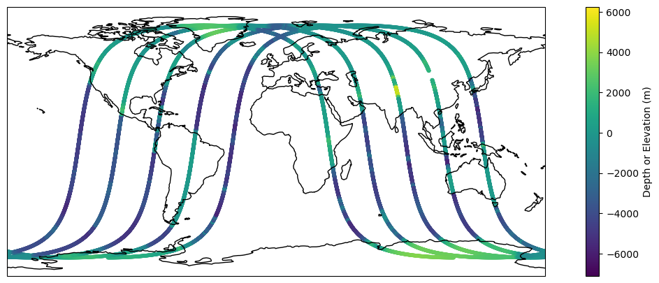
#retrieves granule from the day we wantnadir_results = earthaccess.search_data(short_name ='SWOT_L2_NALT_IGDR_SSHA_2.0', temporal = ("2024-01-30 12:00:00", "2024-01-30 19:43:00"))
#load downloaded data into dataset to be used for plottingds_nadir = xr.open_mfdataset("./data_downloads/SWOT_files/SWOT_IPR_*.nc", combine='nested', concat_dim="time", decode_times=False, engine='h5netcdf', group='data_01')ds_nadir
Time of measurement in seconds in the UTC time scale since 1 Jan 2000 00:00:00 UTC. [tai_utc_difference] is the difference between TAI and UTC reference time (seconds) for the first measurement of the data set. If a leap second occurs within the data set, the attribute [leap_second] is set to the UTC time at which the leap second occurs
Positive latitude is North latitude, negative latitude is South latitude. See SWOT Nadir Altimeter User Handbook. Associated quality flag is orb_state_diode_flag for the OGDR products, orb_state_rest_flag for the IGDR and GDR products
Array
Chunk
Bytes
218.18 kiB
21.92 kiB
Shape
(27927,)
(2806,)
Dask graph
10 chunks in 21 graph layers
Data type
float64 numpy.ndarray
longitude
(time)
float64
dask.array<chunksize=(2806,), meta=np.ndarray>
long_name :
longitude
standard_name :
longitude
units :
degrees_east
comment :
East longitude relative to Greenwich meridian. See SWOT Nadir Altimeter User Handbook. Associated quality flag is orb_state_diode_flag for the OGDR products, orb_state_rest_flag for the IGDR and GDR products
Array
Chunk
Bytes
218.18 kiB
21.92 kiB
Shape
(27927,)
(2806,)
Dask graph
10 chunks in 21 graph layers
Data type
float64 numpy.ndarray
time_tai
(time)
float64
dask.array<chunksize=(2806,), meta=np.ndarray>
long_name :
time in TAI
standard_name :
time
calendar :
gregorian
units :
seconds since 2000-01-01 00:00:00.0
comment :
Time of measurement in seconds in the TAI time scale since 1 Jan 2000 00:00:00 TAI. This time scale contains no leap seconds. The difference (in seconds) with time in UTC is given by the attribute [time:tai_utc_difference]
Array
Chunk
Bytes
218.18 kiB
21.92 kiB
Shape
(27927,)
(2806,)
Dask graph
10 chunks in 21 graph layers
Data type
float64 numpy.ndarray
surface_classification_flag
(time)
float32
dask.array<chunksize=(2806,), meta=np.ndarray>
long_name :
surface classification
flag_meanings :
open_ocean land continental_water aquatic_vegetation continental_ice_snow floating_ice salted_basin
flag_values :
[0 1 2 3 4 5 6]
comment :
Computed from a mask built with MODIS and GlobCover data
Array
Chunk
Bytes
109.09 kiB
10.96 kiB
Shape
(27927,)
(2806,)
Dask graph
10 chunks in 21 graph layers
Data type
float32 numpy.ndarray
rad_side_1_surface_type_flag
(time)
float32
dask.array<chunksize=(2806,), meta=np.ndarray>
long_name :
radiometer surface type from first radiometer
flag_meanings :
open_ocean near_coast land
flag_values :
[0 1 2]
Array
Chunk
Bytes
109.09 kiB
10.96 kiB
Shape
(27927,)
(2806,)
Dask graph
10 chunks in 21 graph layers
Data type
float32 numpy.ndarray
rad_side_2_surface_type_flag
(time)
float32
dask.array<chunksize=(2806,), meta=np.ndarray>
long_name :
radiometer surface type from second radiometer
flag_meanings :
open_ocean near_coast land
flag_values :
[0 1 2]
Array
Chunk
Bytes
109.09 kiB
10.96 kiB
Shape
(27927,)
(2806,)
Dask graph
10 chunks in 21 graph layers
Data type
float32 numpy.ndarray
alt_qual
(time)
float32
dask.array<chunksize=(2806,), meta=np.ndarray>
long_name :
altimeter quality flag
flag_meanings :
good bad
flag_values :
[0 1]
comment :
Compilation of all altimeter flags except altimeter echo type : Set to default in the current issue
Array
Chunk
Bytes
109.09 kiB
10.96 kiB
Shape
(27927,)
(2806,)
Dask graph
10 chunks in 21 graph layers
Data type
float32 numpy.ndarray
rad_qual
(time)
float32
dask.array<chunksize=(2806,), meta=np.ndarray>
long_name :
radiometer quality flag
flag_meanings :
good bad
flag_values :
[0 1]
comment :
Compilation of all radiometer flags except radiometer surface type : Set to default in the current issue
Array
Chunk
Bytes
109.09 kiB
10.96 kiB
Shape
(27927,)
(2806,)
Dask graph
10 chunks in 21 graph layers
Data type
float32 numpy.ndarray
geo_qual
(time)
float32
dask.array<chunksize=(2806,), meta=np.ndarray>
long_name :
geophysical quality flag
flag_meanings :
good bad
flag_values :
[0 1]
comment :
Check on validity of all geophysical fields : Set to default in the current issue
Possible values are: 0 meaning ’2 maps, nominal’ (six hours apart), 1 meaning ’2 maps, degraded’ (more than six hours apart), 2 meaning ’1 map, closest map used’, 3 meaning ’no valid map’
Array
Chunk
Bytes
109.09 kiB
10.96 kiB
Shape
(27927,)
(2806,)
Dask graph
10 chunks in 21 graph layers
Data type
float32 numpy.ndarray
rad_wet_tropo_cor_interp_qual
(time)
float32
dask.array<chunksize=(2806,), meta=np.ndarray>
long_name :
radiometer wet tropospheric correction interpolation quality flag
Altitude of satellite above the reference ellipsoid. Associated quality flag is orb_state_diode_flag for the OGDR products, orb_state_rest_flag for the IGDR and GDR products
Array
Chunk
Bytes
218.18 kiB
21.92 kiB
Shape
(27927,)
(2806,)
Dask graph
10 chunks in 21 graph layers
Data type
float64 numpy.ndarray
model_dry_tropo_cor_zero_altitude
(time)
float64
dask.array<chunksize=(2806,), meta=np.ndarray>
long_name :
model dry tropospheric correction at zero altitude
standard_name :
altimeter_range_correction_due_to_dry_troposphere
source :
European Center for Medium Range Weather Forecasting
institution :
ECMWF
units :
m
comment :
Computed at Mean Sea Level Pressure at the altimeter time-tag from the interpolation of 2 meteorological fields that surround the altimeter time-tag. A dry tropospheric correction must be added (negative value) to the instrument range to correct this range measurement for dry tropospheric range delays of the radar pulse. See SWOT Nadir Altimeter User Handbook
Array
Chunk
Bytes
218.18 kiB
21.92 kiB
Shape
(27927,)
(2806,)
Dask graph
10 chunks in 21 graph layers
Data type
float64 numpy.ndarray
rad_wet_tropo_cor
(time)
float64
dask.array<chunksize=(2806,), meta=np.ndarray>
long_name :
radiometer wet tropospheric correction
standard_name :
altimeter_range_correction_due_to_wet_troposphere
source :
AMR
institution :
NASA/JPL
units :
m
comment :
A wet tropospheric correction must be added (negative value) to the instrument range to correct this range measurement for wet tropospheric range delays of the radar pulse
Array
Chunk
Bytes
218.18 kiB
21.92 kiB
Shape
(27927,)
(2806,)
Dask graph
10 chunks in 21 graph layers
Data type
float64 numpy.ndarray
mean_sea_surface_cnescls
(time)
float64
dask.array<chunksize=(2806,), meta=np.ndarray>
long_name :
mean sea surface height (CNES/CLS solution) above reference ellipsoid
European Center for Medium Range Weather Forecasting
institution :
ECMWF
units :
m
comment :
Computed at the altimeter time-tag from the interpolation of 2 meteorological fields that surround the altimeter time-tag. See SWOT Nadir Altimeter User Handbook
Array
Chunk
Bytes
218.18 kiB
21.92 kiB
Shape
(27927,)
(2806,)
Dask graph
10 chunks in 21 graph layers
Data type
float64 numpy.ndarray
dac
(time)
float64
dask.array<chunksize=(2806,), meta=np.ndarray>
long_name :
dynamic atmospheric correction
institution :
LEGOS/CLS/CNES
units :
m
comment :
Sum of the high frequency fluctuations correction and of the low frequency inverted barometer correction (inv_bar_cor). See SWOT Nadir Altimeter User Handbook
Includes the equilibrium long-period ocean tide height and only the short-period part of the corresponding loading tide. The permanent tide (zero frequency) is not included in this parameter because it is included in the geoid and mean sea surface (geoid, mean_sea_surface_cnescls). To get the total geocentric tide height (FES solution), do: ocean_tide_fes + ocean_tide_non_eq. See SWOT Nadir Altimeter User Handbook
Array
Chunk
Bytes
218.18 kiB
21.92 kiB
Shape
(27927,)
(2806,)
Dask graph
10 chunks in 21 graph layers
Data type
float64 numpy.ndarray
solid_earth_tide
(time)
float64
dask.array<chunksize=(2806,), meta=np.ndarray>
long_name :
solid earth tide height
standard_name :
sea_surface_height_amplitude_due_to_earth_tide
source :
Cartwright and Edden [1973] Corrected tables of tidal harmonics - J. Geophys. J. R. Astr. Soc., 33, 253-264.
units :
m
comment :
Calculated using Cartwright and Tayler tables and consisting of the second and third degree constituents. The permanent tide (zero frequency) is not included. See SWOT Nadir Altimeter User Handbook
Array
Chunk
Bytes
218.18 kiB
21.92 kiB
Shape
(27927,)
(2806,)
Dask graph
10 chunks in 21 graph layers
Data type
float64 numpy.ndarray
pole_tide
(time)
float64
dask.array<chunksize=(2806,), meta=np.ndarray>
long_name :
geocentric pole tide height
standard_name :
sea_surface_height_amplitude_due_to_pole_tide
source :
Desai, S., Wahr, J. & Beckley, B. J Geod [2015] 89: 1233
units :
m
comment :
See SWOT Nadir Altimeter User Handbook
Array
Chunk
Bytes
218.18 kiB
21.92 kiB
Shape
(27927,)
(2806,)
Dask graph
10 chunks in 21 graph layers
Data type
float64 numpy.ndarray
internal_tide_hret
(time)
float64
dask.array<chunksize=(2806,), meta=np.ndarray>
long_name :
internal tide height
source :
E. D. Zaron. Baroclinic tidal sea level from exact-repeat mission altimetry. Journal of Physical Oceanography, 49(1):193-210, 2019.
units :
m
comment :
See SWOT Nadir Altimeter User Handbook
Array
Chunk
Bytes
218.18 kiB
21.92 kiB
Shape
(27927,)
(2806,)
Dask graph
10 chunks in 21 graph layers
Data type
float64 numpy.ndarray
wind_speed_alt
(time)
float64
dask.array<chunksize=(2806,), meta=np.ndarray>
long_name :
altimeter wind speed
standard_name :
wind_speed
units :
m/s
comment :
Should not be used over land. See SWOT Nadir Altimeter User Handbook. A calibration bias of +0.06 dB has been added to the Ku band backscatter coefficient (/data_01/ku/sig0_ocean) before computing the wind speed
Array
Chunk
Bytes
218.18 kiB
21.92 kiB
Shape
(27927,)
(2806,)
Dask graph
10 chunks in 21 graph layers
Data type
float64 numpy.ndarray
wind_speed_alt_mle3
(time)
float64
dask.array<chunksize=(2806,), meta=np.ndarray>
long_name :
altimeter wind speed (MLE3 retracking)
standard_name :
wind_speed
units :
m/s
comment :
Should not be used over land. See SWOT Nadir Altimeter User Handbook. A calibration bias of +0.109 dB has been added to the Ku band backscatter coefficient (/data_01/ku/sig0_ocean_mle3) before computing the wind speed
plt.figure(figsize=(15, 5))ax = plt.axes(projection=ccrs.PlateCarree())ax.set_global()ax.coastlines()plt.scatter(x=ds_nadir.longitude, y=ds_nadir.latitude, c=ds_nadir.depth_or_elevation, marker='.')plt.colorbar().set_label('Depth or Elevation (m)')
3. SWOT Level 2 Radiometer Datasets
Outlined below is a map of the different Radiometer Data Products we host at PO.DAAC, and why you may choose one over the other. For more information, see the SWOT Data User Handbook.
Once you’ve picked the dataset you want to look at, you can search and visualize this dataset in a workflow similar to the above datasets.
A final word…
Accessing data completely in memory are affected by various things. Tools like xarray make a lot of assumptions about how to open and read a file. Sometimes the internals don’t fit the xarray ‘mould’ and we need to continue to work with data providers and software providers to make these two sides work together. Level 2 data (non-gridded), specifically, suffers from some of the assumptions made.