import numpy as np
import pandas as pd
import xarray as xr
import earthaccess
import matplotlib.pyplot as pltFrom the PO.DAAC Cookbook, to access the GitHub version of the notebook, follow this link.
Note: This notebook uses Version C (2.0) of SWOT data that was available at the time of this notebook’s development. The most recent data is now available as Version D for SWOT collections. The last Version C measurement will be until May 3rd, 2025. The first Version D measurement starts on May 5th, 2025.
SWOT Quality Flag Demonstration
Summary:
SWOT standard data products such as L2_LR_SSH include quality flags that communicate detailed information about the quality of the observation reported. SWOT quality flags are paired one-to-one with the core science data variables in each netcdf file. They’re identified by the qual suffix, e.g.
Science data variable:
<variable name>Quality flag variable:
<variable name>_qual
Depending on the data product though, the quality flag may not end with qual, you may need to alter the code for your particular dataset. See the summary chart below.
Quality flags have different syntax depending on which data product is being used. If a measurement has a quality flag, it can also have a bit flag that provides the detail of why the quality flags are set as they are (see Product Description Documents (PDDs) for specific value meanings). In addition to the ‘_qual’ or ‘_q’ indications, ‘_flag’ or ‘_f’ (e.g., ‘ice_flag’) may be used in each data product to raise different flags with unique values and meanings. See specific PDDs for more information.
| SWOT Product | Quality Flag Identifier | Values and Meanings |
|---|---|---|
| L2_HR_RiverSP L2_HR_RiverAvg |
Var + ‘_q’ Overall Quality Variables: ‘reach_q’ or ‘node_q’ Bitwise: Var + ‘_q_b’ |
0 = good 1 = suspect - may have large errors 2 = degraded - likely to have large errors 3 = bad - may be nonsensical and should be ignored For discharge parameters: (e.g., ‘dschg_c_q’) 0 = valid 1 = questionable 2 = invalid |
| L2_HR_LakeSP L2_HR_LakeAvg |
Overall quality Variable: ‘quality_f’ | 0 = good 1 = bad |
| L2_HR_Raster | Var + ‘_qual’ Ex: ‘wse_qual’ Bitwise: Var + ‘_qual_bitwise’ |
0 = good 1 = suspect - may have large errors 2 = degraded - likely to have large errors 3 = bad - may be nonsensical and should be ignored |
| L2_NALT_GDR L2_NALT_IGDR L2_NALT_OGDR L2_RAD_GDR L2_RAD_IGDR L2_RAD_OGDR L2_FPDEM |
Var + ‘_qual’ Ex: ‘rad_water_vapor_qual’ |
0 = good 1 = bad |
| L2_LR_SSH L2_HR_PIXC L1B_HR_SLC L1B_LR_INTF |
Var + ‘_qual’ | Varies, see PDDs |
Quality flags are stored as arrays of integers. Each integer decomposes into a series of bits that individually describe data quality according to various criteria specific to each science data product from SWOT. This example will demonstrate how to interrogate the quality information about the ssha_karin_2 variable in one L2 LR SSH product/file.
Requirement:
This tutorial can be run on a local machine or the AWS cloud, if AWS cloud, it must be an instance running in us-west-2: NASA Earthdata Cloud data in https or S3 can be directly accessed via earthaccess python library.
Learning Objectives:
- Demonstrate how to interrogate the quality information for the ssha_karin_2 variable in one L2 LR SSH product/files, though this process can be used for other SWOT data with associated 8-bit quality flags.
- Filter data via quality flags and visualize
Notebook Author: Jack McNelis, NASA PO.DAAC (April 2024) || Other Contributors: Cassie Nickles (NASA PO.DAAC)
Libraries Needed:
Earthdata Login
An Earthdata Login account is required to access data, as well as discover restricted data, from the NASA Earthdata system. Thus, to access NASA data, you need Earthdata Login. Please visit https://urs.earthdata.nasa.gov to register and manage your Earthdata Login account. This account is free to create and only takes a moment to set up. We use earthaccess to authenticate your login credentials below.
auth = earthaccess.login()Use earthaccess to search SWOT data
Here we use the SSH shortname, SWOT_L2_LR_SSH_Expert_2.0 from Version C of the data.
ssh_results = earthaccess.search_data(short_name = 'SWOT_L2_LR_SSH_Expert_2.0',
                                      temporal = ("2024-03-22 00:00:00", "2024-03-22 23:59:59"))#,
                                     #granule_name = '*_Expert_012_455*') #if you know what cycle and pass you want, you can be more specific
Granules found: 29If accessing via Local Machine
# If you are on a local machine, download the first file to your local computer
earthaccess.download(ssh_results[0], "./data_downloads/SWOT_files")
Getting 1 granules, approx download size: 0.03 GB['data_downloads\\SWOT_files\\SWOT_L2_LR_SSH_Expert_012_428_20240321T235733_20240322T004901_PIC0_01.nc']# Open via xarray
ds = xr.open_mfdataset("./data_downloads/SWOT_files/SWOT_L2_LR_SSH_Expert*.nc")#, mask_and_scale=False)
ds<xarray.Dataset>
Dimensions: (num_lines: 9866, num_pixels: 69,
num_sides: 2)
Coordinates:
latitude (num_lines, num_pixels) float64 dask.array<chunksize=(9866, 69), meta=np.ndarray>
longitude (num_lines, num_pixels) float64 dask.array<chunksize=(9866, 69), meta=np.ndarray>
latitude_nadir (num_lines) float64 dask.array<chunksize=(9866,), meta=np.ndarray>
longitude_nadir (num_lines) float64 dask.array<chunksize=(9866,), meta=np.ndarray>
Dimensions without coordinates: num_lines, num_pixels, num_sides
Data variables: (12/98)
time (num_lines) datetime64[ns] dask.array<chunksize=(9866,), meta=np.ndarray>
time_tai (num_lines) datetime64[ns] dask.array<chunksize=(9866,), meta=np.ndarray>
ssh_karin (num_lines, num_pixels) float64 dask.array<chunksize=(9866, 69), meta=np.ndarray>
ssh_karin_qual (num_lines, num_pixels) float64 dask.array<chunksize=(9866, 69), meta=np.ndarray>
ssh_karin_uncert (num_lines, num_pixels) float32 dask.array<chunksize=(9866, 69), meta=np.ndarray>
ssha_karin (num_lines, num_pixels) float64 dask.array<chunksize=(9866, 69), meta=np.ndarray>
... ...
swh_ssb_cor_source (num_lines, num_pixels) float32 dask.array<chunksize=(9866, 69), meta=np.ndarray>
swh_ssb_cor_source_2 (num_lines, num_pixels) float32 dask.array<chunksize=(9866, 69), meta=np.ndarray>
wind_speed_ssb_cor_source (num_lines, num_pixels) float32 dask.array<chunksize=(9866, 69), meta=np.ndarray>
wind_speed_ssb_cor_source_2 (num_lines, num_pixels) float32 dask.array<chunksize=(9866, 69), meta=np.ndarray>
volumetric_correlation (num_lines, num_pixels) float32 dask.array<chunksize=(9866, 69), meta=np.ndarray>
volumetric_correlation_uncert (num_lines, num_pixels) float32 dask.array<chunksize=(9866, 69), meta=np.ndarray>
Attributes: (12/62)
Conventions: CF-1.7
title: Level 2 Low Rate Sea Surfa...
institution: CNES
source: Ka-band radar interferometer
history: 2024-03-24T22:39:40Z : Cre...
platform: SWOT
... ...
ellipsoid_semi_major_axis: 6378137.0
ellipsoid_flattening: 0.0033528106647474805
good_ocean_data_percent: 67.62656103685167
ssha_variance: 0.7787372594877449
references: V1.2.1
equator_longitude: 52.58If accessing via AWS Cloud
#If you are on the cloud, skip the download step above and access the file via xarray directly
ds = xr.open_mfdataset(earthaccess.open([ssh_results[0]]))#, mask_and_scale=False)
ds
List all L2 LR SSH quality flag variables in a new python dictionary:
quality_variables = {}

for name, variable in ds.variables.items():
    if name.endswith("qual"):
        quality_variables[name] = None

sorted(list(quality_variables))
['height_cor_xover_qual',
'orbit_qual',
'sig0_karin_2_qual',
'sig0_karin_qual',
'ssh_karin_2_qual',
'ssh_karin_qual',
'ssha_karin_2_qual',
'ssha_karin_qual',
'swh_karin_qual',
'wind_speed_karin_2_qual',
'wind_speed_karin_qual']Depending on the data product, the quality flag may not end with qual, you may need to alter the above code for your particular dataset. See the summary chart in the introduction.
For this example, we will use the ssha_karin_2 variable from the L2_LR_SSH dataset.
variable_name = "ssha_karin_2"

quality_variable_name = f"{variable_name}_qual"

print(variable_name, quality_variable_name)
ssha_karin_2 ssha_karin_2_qualSelect the ssha_karin_2_qual variable and print its header information:
qual = ds.variables[quality_variable_name].copy()

print(qual)
<xarray.Variable (num_lines: 9866, num_pixels: 69)>
dask.array<copy, shape=(9866, 69), dtype=float64, chunksize=(9866, 69), chunktype=numpy.ndarray>
Attributes:
long_name: sea surface height anomaly quality flag
standard_name: status_flag
flag_meanings: suspect_large_ssh_delta suspect_large_ssh_std suspect_lar...
flag_masks: [ 1 2 4 8 16 ...
valid_min: 0
valid_max: 3876569055
comment: Quality flag for the SSHA from KaRIn in the ssha_karin_2 ...The flag_meanings and flag_masks attributes define the quality fields/values assigned to each bit (and/or sequence of bits) comprising the integers in the quality variable array. (Refer to the CF Conventions documentation and SWOT PDDs for additional info about standard attributes stored in each netcdf file from SWOT.) The flag meanings/masks attributes are typically space-delimited strings.
Make a simple lookup table for the ssha_karin_2_qual variable:
atts = dict(qual.attrs.copy())

flags = pd.DataFrame({'flag_meanings': atts.get("flag_meanings").split(" "),
                      'flag_masks': atts.get("flag_masks"), }) \
          .set_index("flag_meanings")

display(flags)| flag_masks | |
|---|---|
| flag_meanings | |
| suspect_large_ssh_delta | 1 |
| suspect_large_ssh_std | 2 |
| suspect_large_ssh_window_std | 4 |
| suspect_beam_used | 8 |
| suspect_less_than_nine_beams | 16 |
| suspect_ssb_out_of_range | 64 |
| suspect_pixel_used | 128 |
| suspect_num_pt_avg | 256 |
| suspect_karin_telem | 512 |
| suspect_orbit_control | 1024 |
| suspect_sc_event_flag | 2048 |
| suspect_tvp_qual | 4096 |
| suspect_volumetric_corr | 8192 |
| degraded_ssb_not_computable | 32768 |
| degraded_media_delays_missing | 65536 |
| degraded_beam_used | 131072 |
| degraded_large_attitude | 262144 |
| degraded_karin_ifft_overflow | 524288 |
| bad_karin_telem | 16777216 |
| bad_very_large_attitude | 33554432 |
| bad_tide_corrections_missing | 67108864 |
| bad_outside_of_range | 536870912 |
| degraded | 1073741824 |
| bad_not_usable | 2147483648 |
Now print the list of unique integer values in the ssha_karin_2_qual variable array. Each value is a sum of an assortment of the numbers above we made in our lookup table. We will decode the quality bits for each one in a new column of our lookup table.
unq_ints_qual = sorted(list(set(qual.load().data.astype(np.int64).flatten().tolist())))

print(f"\n# Counted {len(unq_ints_qual)} unique integers in '{quality_variable_name}' variable array:\n\n{unq_ints_qual}\n")
# Counted 385 unique integers in 'ssha_karin_2_qual' variable array:

[0, 1, 4, 5, 128, 129, 130, 132, 133, 134, 135, 144, 145, 146, 148, 149, 150, 256, 257, 258, 261, 384, 385, 386, 388, 389, 390, 391, 400, 401, 402, 404, 405, 406, 407, 2184, 2185, 2186, 2188, 2189, 2190, 2191, 2200, 2201, 2204, 2205, 2206, 2207, 2440, 2441, 2442, 2444, 2445, 2446, 2447, 2456, 2457, 2458, 2460, 2461, 2462, 2463, 8328, 8329, 8332, 8333, 8344, 8345, 8346, 8348, 8349, 8350, 8584, 8585, 8586, 8588, 8589, 8590, 8591, 8600, 8601, 8602, 8604, 8605, 8606, 8607, 10376, 10380, 10381, 10392, 10393, 10396, 10397, 10398, 10632, 10633, 10634, 10636, 10637, 10638, 10639, 10648, 10649, 10650, 10652, 10653, 10654, 10655, 1073774592, 1073774593, 1073774594, 1073774596, 1073774597, 1073774608, 1073774609, 1073774613, 1073774720, 1073774721, 1073774724, 1073774725, 1073774736, 1073774737, 1073774741, 1073774848, 1073774849, 1073774850, 1073774852, 1073774853, 1073774854, 1073774855, 1073774864, 1073774865, 1073774866, 1073774868, 1073774869, 1073774870, 1073774976, 1073774977, 1073774978, 1073774980, 1073774981, 1073774992, 1073774993, 1073774994, 1073774996, 1073774997, 1073774998, 1073782792, 1073782793, 1073782920, 1073782921, 1073782936, 1073782937, 1073782941, 1073783053, 1073783064, 1073783176, 1073783177, 1073783178, 1073783192, 1073783193, 1073783194, 1073783196, 1073783197, 1073783198, 1073783199, 1074397184, 1074397185, 1074397188, 1074397189, 1074397200, 1074397201, 1074397204, 1074397205, 1074397312, 1074397313, 1074397316, 1074397317, 1074397328, 1074397329, 1074397332, 1074397333, 1074397440, 1074397441, 1074397442, 1074397444, 1074397445, 1074397446, 1074397447, 1074397456, 1074397457, 1074397458, 1074397460, 1074397461, 1074397462, 1074397463, 1074397568, 1074397569, 1074397570, 1074397572, 1074397573, 1074397574, 1074397575, 1074397584, 1074397585, 1074397586, 1074397588, 1074397589, 1074397590, 1074397591, 1074399232, 1074399233, 1074399236, 1074399237, 1074399240, 1074399241, 1074399244, 1074399245, 1074399248, 1074399249, 1074399252, 1074399253, 1074399256, 1074399257, 1074399260, 1074399261, 1074399369, 1074399372, 1074399373, 1074399385, 1074399388, 1074399389, 1074399488, 1074399489, 1074399492, 1074399493, 1074399494, 1074399496, 1074399497, 1074399500, 1074399501, 1074399502, 1074399503, 1074399504, 1074399505, 1074399506, 1074399508, 1074399509, 1074399510, 1074399512, 1074399513, 1074399514, 1074399516, 1074399517, 1074399518, 1074399519, 1074399624, 1074399625, 1074399626, 1074399628, 1074399629, 1074399630, 1074399631, 1074399640, 1074399641, 1074399642, 1074399644, 1074399645, 1074399646, 1074399647, 1074405376, 1074405377, 1074405381, 1074405384, 1074405385, 1074405392, 1074405393, 1074405396, 1074405397, 1074405400, 1074405401, 1074405405, 1074405521, 1074405525, 1074405528, 1074405529, 1074405532, 1074405533, 1074405632, 1074405633, 1074405637, 1074405640, 1074405641, 1074405648, 1074405649, 1074405650, 1074405652, 1074405653, 1074405656, 1074405657, 1074405658, 1074405660, 1074405661, 1074405662, 1074405769, 1074405773, 1074405776, 1074405777, 1074405780, 1074405781, 1074405784, 1074405785, 1074405786, 1074405788, 1074405789, 1074405790, 1074407436, 1074407437, 1074407440, 1074407441, 1074407444, 1074407445, 1074407448, 1074407449, 1074407452, 1074407453, 1074407564, 1074407576, 1074407577, 1074407581, 1074407688, 1074407692, 1074407693, 1074407696, 1074407697, 1074407700, 1074407701, 1074407704, 1074407705, 1074407708, 1074407709, 1074407816, 1074407817, 1074407818, 1074407820, 1074407821, 1074407832, 1074407833, 1074407834, 1074407836, 1074407837, 1074407838, 1074407839, 1074429952, 1074429953, 1074429957, 1074429968, 1074429969, 1074429972, 1074430097, 1074430208, 1074430210, 1074430212, 1074430213, 1074430224, 1074430225, 1074430228, 1074430352, 1074430353, 1074430356, 1074438145, 1074438148, 1074438161, 1074438164, 1074438420, 1074438421, 1074438548, 1074438549, 1074438552, 1074438553, 1074438556, 1074438557, 2684354816, 2684354820, 2751463684]
Create a bitwise True/False mapping for each unique integer in the ssha_karin_2_qual array.
It’s often advantageous to construct a data mask based on the pixels/cells that you’d like to include in your analysis (rather than exclude from it; masking in vs. masking out).
def qual_bits_iter(n):
    while n:
        b = n & (~n+1)
        yield b
        n ^= b

decomposed_qual = {}
for i in sorted(unq_ints_qual):
    if i not in decomposed_qual:
        decomposed_qual[i] = qual_bits_iter(i)

type(decomposed_qual), len(decomposed_qual)
(dict, 385)Add one new column for each unique integer in the ssha_karin_qual variable. Highlight table cells that contain True, which indicates the quality criteria on the left/index applies to the pixels/cells in ssha_karin wherever the ssha_karin_qual array contains one of the corresponding integers.
new_columns_qual = {}
for i, j in enumerate(list(set(decomposed_qual))):
    new_columns_qual[j] = flags['flag_masks'] \
        .apply(lambda x: x in [b for b in qual_bits_iter(j)])

lookup = flags.join(pd.DataFrame(new_columns_qual).sort_index(axis=1)).copy()

display(lookup.style.apply(lambda x: ['background-color:yellow' if all([i,type(i)==bool]) else '' for i in x]))| flag_masks | 0 | 1 | 4 | 5 | 128 | 129 | 130 | 132 | 133 | 134 | 135 | 144 | 145 | 146 | 148 | 149 | 150 | 256 | 257 | 258 | 261 | 384 | 385 | 386 | 388 | 389 | 390 | 391 | 400 | 401 | 402 | 404 | 405 | 406 | 407 | 2184 | 2185 | 2186 | 2188 | 2189 | 2190 | 2191 | 2200 | 2201 | 2204 | 2205 | 2206 | 2207 | 2440 | 2441 | 2442 | 2444 | 2445 | 2446 | 2447 | 2456 | 2457 | 2458 | 2460 | 2461 | 2462 | 2463 | 8328 | 8329 | 8332 | 8333 | 8344 | 8345 | 8346 | 8348 | 8349 | 8350 | 8584 | 8585 | 8586 | 8588 | 8589 | 8590 | 8591 | 8600 | 8601 | 8602 | 8604 | 8605 | 8606 | 8607 | 10376 | 10380 | 10381 | 10392 | 10393 | 10396 | 10397 | 10398 | 10632 | 10633 | 10634 | 10636 | 10637 | 10638 | 10639 | 10648 | 10649 | 10650 | 10652 | 10653 | 10654 | 10655 | 1073774592 | 1073774593 | 1073774594 | 1073774596 | 1073774597 | 1073774608 | 1073774609 | 1073774613 | 1073774720 | 1073774721 | 1073774724 | 1073774725 | 1073774736 | 1073774737 | 1073774741 | 1073774848 | 1073774849 | 1073774850 | 1073774852 | 1073774853 | 1073774854 | 1073774855 | 1073774864 | 1073774865 | 1073774866 | 1073774868 | 1073774869 | 1073774870 | 1073774976 | 1073774977 | 1073774978 | 1073774980 | 1073774981 | 1073774992 | 1073774993 | 1073774994 | 1073774996 | 1073774997 | 1073774998 | 1073782792 | 1073782793 | 1073782920 | 1073782921 | 1073782936 | 1073782937 | 1073782941 | 1073783053 | 1073783064 | 1073783176 | 1073783177 | 1073783178 | 1073783192 | 1073783193 | 1073783194 | 1073783196 | 1073783197 | 1073783198 | 1073783199 | 1074397184 | 1074397185 | 1074397188 | 1074397189 | 1074397200 | 1074397201 | 1074397204 | 1074397205 | 1074397312 | 1074397313 | 1074397316 | 1074397317 | 1074397328 | 1074397329 | 1074397332 | 1074397333 | 1074397440 | 1074397441 | 1074397442 | 1074397444 | 1074397445 | 1074397446 | 1074397447 | 1074397456 | 1074397457 | 1074397458 | 1074397460 | 1074397461 | 1074397462 | 1074397463 | 1074397568 | 1074397569 | 1074397570 | 1074397572 | 1074397573 | 1074397574 | 1074397575 | 1074397584 | 1074397585 | 1074397586 | 1074397588 | 1074397589 | 1074397590 | 1074397591 | 1074399232 | 1074399233 | 1074399236 | 1074399237 | 1074399240 | 1074399241 | 1074399244 | 1074399245 | 1074399248 | 1074399249 | 1074399252 | 1074399253 | 1074399256 | 1074399257 | 1074399260 | 1074399261 | 1074399369 | 1074399372 | 1074399373 | 1074399385 | 1074399388 | 1074399389 | 1074399488 | 1074399489 | 1074399492 | 1074399493 | 1074399494 | 1074399496 | 1074399497 | 1074399500 | 1074399501 | 1074399502 | 1074399503 | 1074399504 | 1074399505 | 1074399506 | 1074399508 | 1074399509 | 1074399510 | 1074399512 | 1074399513 | 1074399514 | 1074399516 | 1074399517 | 1074399518 | 1074399519 | 1074399624 | 1074399625 | 1074399626 | 1074399628 | 1074399629 | 1074399630 | 1074399631 | 1074399640 | 1074399641 | 1074399642 | 1074399644 | 1074399645 | 1074399646 | 1074399647 | 1074405376 | 1074405377 | 1074405381 | 1074405384 | 1074405385 | 1074405392 | 1074405393 | 1074405396 | 1074405397 | 1074405400 | 1074405401 | 1074405405 | 1074405521 | 1074405525 | 1074405528 | 1074405529 | 1074405532 | 1074405533 | 1074405632 | 1074405633 | 1074405637 | 1074405640 | 1074405641 | 1074405648 | 1074405649 | 1074405650 | 1074405652 | 1074405653 | 1074405656 | 1074405657 | 1074405658 | 1074405660 | 1074405661 | 1074405662 | 1074405769 | 1074405773 | 1074405776 | 1074405777 | 1074405780 | 1074405781 | 1074405784 | 1074405785 | 1074405786 | 1074405788 | 1074405789 | 1074405790 | 1074407436 | 1074407437 | 1074407440 | 1074407441 | 1074407444 | 1074407445 | 1074407448 | 1074407449 | 1074407452 | 1074407453 | 1074407564 | 1074407576 | 1074407577 | 1074407581 | 1074407688 | 1074407692 | 1074407693 | 1074407696 | 1074407697 | 1074407700 | 1074407701 | 1074407704 | 1074407705 | 1074407708 | 1074407709 | 1074407816 | 1074407817 | 1074407818 | 1074407820 | 1074407821 | 1074407832 | 1074407833 | 1074407834 | 1074407836 | 1074407837 | 1074407838 | 1074407839 | 1074429952 | 1074429953 | 1074429957 | 1074429968 | 1074429969 | 1074429972 | 1074430097 | 1074430208 | 1074430210 | 1074430212 | 1074430213 | 1074430224 | 1074430225 | 1074430228 | 1074430352 | 1074430353 | 1074430356 | 1074438145 | 1074438148 | 1074438161 | 1074438164 | 1074438420 | 1074438421 | 1074438548 | 1074438549 | 1074438552 | 1074438553 | 1074438556 | 1074438557 | 2684354816 | 2684354820 | 2751463684 | |
|---|---|---|---|---|---|---|---|---|---|---|---|---|---|---|---|---|---|---|---|---|---|---|---|---|---|---|---|---|---|---|---|---|---|---|---|---|---|---|---|---|---|---|---|---|---|---|---|---|---|---|---|---|---|---|---|---|---|---|---|---|---|---|---|---|---|---|---|---|---|---|---|---|---|---|---|---|---|---|---|---|---|---|---|---|---|---|---|---|---|---|---|---|---|---|---|---|---|---|---|---|---|---|---|---|---|---|---|---|---|---|---|---|---|---|---|---|---|---|---|---|---|---|---|---|---|---|---|---|---|---|---|---|---|---|---|---|---|---|---|---|---|---|---|---|---|---|---|---|---|---|---|---|---|---|---|---|---|---|---|---|---|---|---|---|---|---|---|---|---|---|---|---|---|---|---|---|---|---|---|---|---|---|---|---|---|---|---|---|---|---|---|---|---|---|---|---|---|---|---|---|---|---|---|---|---|---|---|---|---|---|---|---|---|---|---|---|---|---|---|---|---|---|---|---|---|---|---|---|---|---|---|---|---|---|---|---|---|---|---|---|---|---|---|---|---|---|---|---|---|---|---|---|---|---|---|---|---|---|---|---|---|---|---|---|---|---|---|---|---|---|---|---|---|---|---|---|---|---|---|---|---|---|---|---|---|---|---|---|---|---|---|---|---|---|---|---|---|---|---|---|---|---|---|---|---|---|---|---|---|---|---|---|---|---|---|---|---|---|---|---|---|---|---|---|---|---|---|---|---|---|---|---|---|---|---|---|---|---|---|---|---|---|---|---|---|---|---|---|---|---|---|---|---|---|---|---|---|---|---|---|---|---|---|---|---|---|---|---|---|---|---|---|---|---|---|---|---|---|---|---|---|---|---|---|---|---|
| flag_meanings | ||||||||||||||||||||||||||||||||||||||||||||||||||||||||||||||||||||||||||||||||||||||||||||||||||||||||||||||||||||||||||||||||||||||||||||||||||||||||||||||||||||||||||||||||||||||||||||||||||||||||||||||||||||||||||||||||||||||||||||||||||||||||||||||||||||||||||||||||||||||||||||||||||||||||||||||||||||||||||||||||||||||||||||||||||||||||||||||||||||||||||||||||||||||||||||||||||
| suspect_large_ssh_delta | 1 | False | True | False | True | False | True | False | False | True | False | True | False | True | False | False | True | False | False | True | False | True | False | True | False | False | True | False | True | False | True | False | False | True | False | True | False | True | False | False | True | False | True | False | True | False | True | False | True | False | True | False | False | True | False | True | False | True | False | False | True | False | True | False | True | False | True | False | True | False | False | True | False | False | True | False | False | True | False | True | False | True | False | False | True | False | True | False | False | True | False | True | False | True | False | False | True | False | False | True | False | True | False | True | False | False | True | False | True | False | True | False | False | True | False | True | True | False | True | False | True | False | True | True | False | True | False | False | True | False | True | False | True | False | False | True | False | False | True | False | False | True | False | True | False | False | True | False | False | True | False | True | False | True | True | True | False | False | True | False | False | True | False | False | True | False | True | False | True | False | True | False | True | False | True | False | True | False | True | False | True | False | True | False | True | False | False | True | False | True | False | True | False | False | True | False | True | False | True | False | False | True | False | True | False | True | False | False | True | False | True | False | True | False | True | False | True | False | True | False | True | False | True | False | True | False | True | True | False | True | True | False | True | False | True | False | True | False | False | True | False | True | False | True | False | True | False | False | True | False | False | True | False | False | True | False | True | False | True | False | False | True | False | True | False | True | False | False | True | False | True | False | True | True | False | True | False | True | False | True | False | True | True | True | True | False | True | False | True | False | True | True | False | True | False | True | False | False | True | False | True | False | False | True | False | True | True | False | True | False | True | False | True | False | False | True | False | False | True | False | True | False | True | False | True | False | True | False | False | True | True | False | False | True | False | True | False | True | False | True | False | True | False | True | False | False | True | False | True | False | False | True | False | True | False | True | True | False | True | False | True | False | False | False | True | False | True | False | False | True | False | True | False | True | False | False | True | False | True | False | True | False | True | False | False | False |
| suspect_large_ssh_std | 2 | False | False | False | False | False | False | True | False | False | True | True | False | False | True | False | False | True | False | False | True | False | False | False | True | False | False | True | True | False | False | True | False | False | True | True | False | False | True | False | False | True | True | False | False | False | False | True | True | False | False | True | False | False | True | True | False | False | True | False | False | True | True | False | False | False | False | False | False | True | False | False | True | False | False | True | False | False | True | True | False | False | True | False | False | True | True | False | False | False | False | False | False | False | True | False | False | True | False | False | True | True | False | False | True | False | False | True | True | False | False | True | False | False | False | False | False | False | False | False | False | False | False | False | False | False | True | False | False | True | True | False | False | True | False | False | True | False | False | True | False | False | False | False | True | False | False | True | False | False | False | False | False | False | False | False | False | False | False | True | False | False | True | False | False | True | True | False | False | False | False | False | False | False | False | False | False | False | False | False | False | False | False | False | False | True | False | False | True | True | False | False | True | False | False | True | True | False | False | True | False | False | True | True | False | False | True | False | False | True | True | False | False | False | False | False | False | False | False | False | False | False | False | False | False | False | False | False | False | False | False | False | False | False | False | False | False | True | False | False | False | False | True | True | False | False | True | False | False | True | False | False | True | False | False | True | True | False | False | True | False | False | True | True | False | False | True | False | False | True | True | False | False | False | False | False | False | False | False | False | False | False | False | False | False | False | False | False | False | False | False | False | False | False | False | False | True | False | False | False | False | True | False | False | True | False | False | False | False | False | False | False | False | True | False | False | True | False | False | False | False | False | False | False | False | False | False | False | False | False | False | False | False | False | False | False | False | False | False | False | False | False | False | False | True | False | False | False | False | True | False | False | True | True | False | False | False | False | False | False | False | False | True | False | False | False | False | False | False | False | False | False | False | False | False | False | False | False | False | False | False | False | False | False | False | False |
| suspect_large_ssh_window_std | 4 | False | False | True | True | False | False | False | True | True | True | True | False | False | False | True | True | True | False | False | False | True | False | False | False | True | True | True | True | False | False | False | True | True | True | True | False | False | False | True | True | True | True | False | False | True | True | True | True | False | False | False | True | True | True | True | False | False | False | True | True | True | True | False | False | True | True | False | False | False | True | True | True | False | False | False | True | True | True | True | False | False | False | True | True | True | True | False | True | True | False | False | True | True | True | False | False | False | True | True | True | True | False | False | False | True | True | True | True | False | False | False | True | True | False | False | True | False | False | True | True | False | False | True | False | False | False | True | True | True | True | False | False | False | True | True | True | False | False | False | True | True | False | False | False | True | True | True | False | False | False | False | False | False | True | True | False | False | False | False | False | False | False | True | True | True | True | False | False | True | True | False | False | True | True | False | False | True | True | False | False | True | True | False | False | False | True | True | True | True | False | False | False | True | True | True | True | False | False | False | True | True | True | True | False | False | False | True | True | True | True | False | False | True | True | False | False | True | True | False | False | True | True | False | False | True | True | False | True | True | False | True | True | False | False | True | True | True | False | False | True | True | True | True | False | False | False | True | True | True | False | False | False | True | True | True | True | False | False | False | True | True | True | True | False | False | False | True | True | True | True | False | False | True | False | False | False | False | True | True | False | False | True | False | True | False | False | True | True | False | False | True | False | False | False | False | False | True | True | False | False | False | True | True | True | False | True | False | False | True | True | False | False | False | True | True | True | True | True | False | False | True | True | False | False | True | True | True | False | False | True | False | True | True | False | False | True | True | False | False | True | True | False | False | False | True | True | False | False | False | True | True | True | True | False | False | True | False | False | True | False | False | False | True | True | False | False | True | False | False | True | False | True | False | True | True | True | True | True | False | False | True | True | False | True | True |
| suspect_beam_used | 8 | False | False | False | False | False | False | False | False | False | False | False | False | False | False | False | False | False | False | False | False | False | False | False | False | False | False | False | False | False | False | False | False | False | False | False | True | True | True | True | True | True | True | True | True | True | True | True | True | True | True | True | True | True | True | True | True | True | True | True | True | True | True | True | True | True | True | True | True | True | True | True | True | True | True | True | True | True | True | True | True | True | True | True | True | True | True | True | True | True | True | True | True | True | True | True | True | True | True | True | True | True | True | True | True | True | True | True | True | False | False | False | False | False | False | False | False | False | False | False | False | False | False | False | False | False | False | False | False | False | False | False | False | False | False | False | False | False | False | False | False | False | False | False | False | False | False | False | True | True | True | True | True | True | True | True | True | True | True | True | True | True | True | True | True | True | True | False | False | False | False | False | False | False | False | False | False | False | False | False | False | False | False | False | False | False | False | False | False | False | False | False | False | False | False | False | False | False | False | False | False | False | False | False | False | False | False | False | False | False | False | False | False | False | False | True | True | True | True | False | False | False | False | True | True | True | True | True | True | True | True | True | True | False | False | False | False | False | True | True | True | True | True | True | False | False | False | False | False | False | True | True | True | True | True | True | True | True | True | True | True | True | True | True | True | True | True | True | True | True | True | False | False | False | True | True | False | False | False | False | True | True | True | False | False | True | True | True | True | False | False | False | True | True | False | False | False | False | False | True | True | True | True | True | True | True | True | False | False | False | False | True | True | True | True | True | True | True | True | False | False | False | False | True | True | True | True | True | True | True | True | True | True | True | False | False | False | False | True | True | True | True | True | True | True | True | True | True | True | True | True | True | True | True | False | False | False | False | False | False | False | False | False | False | False | False | False | False | False | False | False | False | False | False | False | False | False | False | False | True | True | True | True | False | False | False |
| suspect_less_than_nine_beams | 16 | False | False | False | False | False | False | False | False | False | False | False | True | True | True | True | True | True | False | False | False | False | False | False | False | False | False | False | False | True | True | True | True | True | True | True | False | False | False | False | False | False | False | True | True | True | True | True | True | False | False | False | False | False | False | False | True | True | True | True | True | True | True | False | False | False | False | True | True | True | True | True | True | False | False | False | False | False | False | False | True | True | True | True | True | True | True | False | False | False | True | True | True | True | True | False | False | False | False | False | False | False | True | True | True | True | True | True | True | False | False | False | False | False | True | True | True | False | False | False | False | True | True | True | False | False | False | False | False | False | False | True | True | True | True | True | True | False | False | False | False | False | True | True | True | True | True | True | False | False | False | False | True | True | True | False | True | False | False | False | True | True | True | True | True | True | True | False | False | False | False | True | True | True | True | False | False | False | False | True | True | True | True | False | False | False | False | False | False | False | True | True | True | True | True | True | True | False | False | False | False | False | False | False | True | True | True | True | True | True | True | False | False | False | False | False | False | False | False | True | True | True | True | True | True | True | True | False | False | False | True | True | True | False | False | False | False | False | False | False | False | False | False | False | True | True | True | True | True | True | True | True | True | True | True | True | True | False | False | False | False | False | False | False | True | True | True | True | True | True | True | False | False | False | False | False | True | True | True | True | True | True | True | True | True | True | True | True | True | False | False | False | False | False | True | True | True | True | True | True | True | True | True | True | True | False | False | True | True | True | True | True | True | True | True | True | True | False | False | True | True | True | True | True | True | True | True | False | True | True | True | False | False | False | True | True | True | True | True | True | True | True | False | False | False | False | False | True | True | True | True | True | True | True | False | False | False | True | True | True | True | False | False | False | False | True | True | True | True | True | True | False | False | True | True | True | True | True | True | True | True | True | True | False | False | False |
| suspect_ssb_out_of_range | 64 | False | False | False | False | False | False | False | False | False | False | False | False | False | False | False | False | False | False | False | False | False | False | False | False | False | False | False | False | False | False | False | False | False | False | False | False | False | False | False | False | False | False | False | False | False | False | False | False | False | False | False | False | False | False | False | False | False | False | False | False | False | False | False | False | False | False | False | False | False | False | False | False | False | False | False | False | False | False | False | False | False | False | False | False | False | False | False | False | False | False | False | False | False | False | False | False | False | False | False | False | False | False | False | False | False | False | False | False | False | False | False | False | False | False | False | False | False | False | False | False | False | False | False | False | False | False | False | False | False | False | False | False | False | False | False | False | False | False | False | False | False | False | False | False | False | False | False | False | False | False | False | False | False | False | False | False | False | False | False | False | False | False | False | False | False | False | False | False | False | False | False | False | False | False | False | False | False | False | False | False | False | False | False | False | False | False | False | False | False | False | False | False | False | False | False | False | False | False | False | False | False | False | False | False | False | False | False | False | False | False | False | False | False | False | False | False | False | False | False | False | False | False | False | False | False | False | False | False | False | False | False | False | False | False | False | False | False | False | False | False | False | False | False | False | False | False | False | False | False | False | False | False | False | False | False | False | False | False | False | False | False | False | False | False | False | False | False | False | False | False | False | False | False | False | False | False | False | False | False | False | False | False | False | False | False | False | False | False | False | False | False | False | False | False | False | False | False | False | False | False | False | False | False | False | False | False | False | False | False | False | False | False | False | False | False | False | False | False | False | False | False | False | False | False | False | False | False | False | False | False | False | False | False | False | False | False | False | False | False | False | False | False | False | False | False | False | False | False | False | False | False | False | False | False | False | False | False | False | False | False | False | False | False | False | False | False | False | False | False | False | False | False | False | False | False | False | False | False | False | False | False | False | False | False | False |
| suspect_pixel_used | 128 | False | False | False | False | True | True | True | True | True | True | True | True | True | True | True | True | True | False | False | False | False | True | True | True | True | True | True | True | True | True | True | True | True | True | True | True | True | True | True | True | True | True | True | True | True | True | True | True | True | True | True | True | True | True | True | True | True | True | True | True | True | True | True | True | True | True | True | True | True | True | True | True | True | True | True | True | True | True | True | True | True | True | True | True | True | True | True | True | True | True | True | True | True | True | True | True | True | True | True | True | True | True | True | True | True | True | True | True | False | False | False | False | False | False | False | False | True | True | True | True | True | True | True | False | False | False | False | False | False | False | False | False | False | False | False | False | True | True | True | True | True | True | True | True | True | True | True | False | False | True | True | True | True | True | False | False | True | True | True | True | True | True | True | True | True | True | False | False | False | False | False | False | False | False | True | True | True | True | True | True | True | True | False | False | False | False | False | False | False | False | False | False | False | False | False | False | True | True | True | True | True | True | True | True | True | True | True | True | True | True | False | False | False | False | False | False | False | False | False | False | False | False | False | False | False | False | True | True | True | True | True | True | False | False | False | False | False | False | False | False | False | False | False | False | False | False | False | False | False | False | False | False | False | False | False | False | True | True | True | True | True | True | True | True | True | True | True | True | True | True | False | False | False | False | False | False | False | False | False | False | False | False | True | True | True | True | True | True | False | False | False | False | False | False | False | False | False | False | False | False | False | False | False | False | True | True | True | True | True | True | True | True | True | True | True | True | False | False | False | False | False | False | False | False | False | False | True | True | True | True | False | False | False | False | False | False | False | False | False | False | False | True | True | True | True | True | True | True | True | True | True | True | True | False | False | False | False | False | False | True | False | False | False | False | False | False | False | True | True | True | False | False | False | False | False | False | True | True | True | True | True | True | False | False | False |
| suspect_num_pt_avg | 256 | False | False | False | False | False | False | False | False | False | False | False | False | False | False | False | False | False | True | True | True | True | True | True | True | True | True | True | True | True | True | True | True | True | True | True | False | False | False | False | False | False | False | False | False | False | False | False | False | True | True | True | True | True | True | True | True | True | True | True | True | True | True | False | False | False | False | False | False | False | False | False | False | True | True | True | True | True | True | True | True | True | True | True | True | True | True | False | False | False | False | False | False | False | False | True | True | True | True | True | True | True | True | True | True | True | True | True | True | False | False | False | False | False | False | False | False | False | False | False | False | False | False | False | True | True | True | True | True | True | True | True | True | True | True | True | True | True | True | True | True | True | True | True | True | True | True | True | False | False | False | False | False | False | False | True | True | True | True | True | True | True | True | True | True | True | True | False | False | False | False | False | False | False | False | False | False | False | False | False | False | False | False | True | True | True | True | True | True | True | True | True | True | True | True | True | True | True | True | True | True | True | True | True | True | True | True | True | True | True | True | False | False | False | False | False | False | False | False | False | False | False | False | False | False | False | False | False | False | False | False | False | False | True | True | True | True | True | True | True | True | True | True | True | True | True | True | True | True | True | True | True | True | True | True | True | True | True | True | True | True | True | True | True | True | True | True | True | True | True | True | False | False | False | False | False | False | False | False | False | False | False | False | False | False | False | False | False | False | True | True | True | True | True | True | True | True | True | True | True | True | True | True | True | True | True | True | True | True | True | True | True | True | True | True | True | True | False | False | False | False | False | False | False | False | False | False | False | False | False | False | True | True | True | True | True | True | True | True | True | True | True | True | True | True | True | True | True | True | True | True | True | True | True | False | False | False | False | False | False | False | True | True | True | True | True | True | True | True | True | True | False | False | False | False | True | True | True | True | True | True | True | True | True | True | True |
| suspect_karin_telem | 512 | False | False | False | False | False | False | False | False | False | False | False | False | False | False | False | False | False | False | False | False | False | False | False | False | False | False | False | False | False | False | False | False | False | False | False | False | False | False | False | False | False | False | False | False | False | False | False | False | False | False | False | False | False | False | False | False | False | False | False | False | False | False | False | False | False | False | False | False | False | False | False | False | False | False | False | False | False | False | False | False | False | False | False | False | False | False | False | False | False | False | False | False | False | False | False | False | False | False | False | False | False | False | False | False | False | False | False | False | False | False | False | False | False | False | False | False | False | False | False | False | False | False | False | False | False | False | False | False | False | False | False | False | False | False | False | False | False | False | False | False | False | False | False | False | False | False | False | False | False | False | False | False | False | False | False | False | False | False | False | False | False | False | False | False | False | False | False | False | False | False | False | False | False | False | False | False | False | False | False | False | False | False | False | False | False | False | False | False | False | False | False | False | False | False | False | False | False | False | False | False | False | False | False | False | False | False | False | False | False | False | False | False | False | False | False | False | False | False | False | False | False | False | False | False | False | False | False | False | False | False | False | False | False | False | False | False | False | False | False | False | False | False | False | False | False | False | False | False | False | False | False | False | False | False | False | False | False | False | False | False | False | False | False | False | False | False | False | False | False | False | False | False | False | False | False | False | False | False | False | False | False | False | False | False | False | False | False | False | False | False | False | False | False | False | False | False | False | False | False | False | False | False | False | False | False | False | False | False | False | False | False | False | False | False | False | False | False | False | False | False | False | False | False | False | False | False | False | False | False | False | False | False | False | False | False | False | False | False | False | False | False | False | False | False | False | False | False | False | False | False | False | False | False | False | False | False | False | False | False | False | False | False | False | False | False | False | False | False | False | False | False | False | False | False | False | False | False | False | False | False | False | False | False | False | False |
| suspect_orbit_control | 1024 | False | False | False | False | False | False | False | False | False | False | False | False | False | False | False | False | False | False | False | False | False | False | False | False | False | False | False | False | False | False | False | False | False | False | False | False | False | False | False | False | False | False | False | False | False | False | False | False | False | False | False | False | False | False | False | False | False | False | False | False | False | False | False | False | False | False | False | False | False | False | False | False | False | False | False | False | False | False | False | False | False | False | False | False | False | False | False | False | False | False | False | False | False | False | False | False | False | False | False | False | False | False | False | False | False | False | False | False | False | False | False | False | False | False | False | False | False | False | False | False | False | False | False | False | False | False | False | False | False | False | False | False | False | False | False | False | False | False | False | False | False | False | False | False | False | False | False | False | False | False | False | False | False | False | False | False | False | False | False | False | False | False | False | False | False | False | False | False | False | False | False | False | False | False | False | False | False | False | False | False | False | False | False | False | False | False | False | False | False | False | False | False | False | False | False | False | False | False | False | False | False | False | False | False | False | False | False | False | False | False | False | False | False | False | False | False | False | False | False | False | False | False | False | False | False | False | False | False | False | False | False | False | False | False | False | False | False | False | False | False | False | False | False | False | False | False | False | False | False | False | False | False | False | False | False | False | False | False | False | False | False | False | False | False | False | False | False | False | False | False | False | False | False | False | False | False | False | False | False | False | False | False | False | False | False | False | False | False | False | False | False | False | False | False | False | False | False | False | False | False | False | False | False | False | False | False | False | False | False | False | False | False | False | False | False | False | False | False | False | False | False | False | False | False | False | False | False | False | False | False | False | False | False | False | False | False | False | False | False | False | False | False | False | False | False | False | False | False | False | False | False | False | False | False | False | False | False | False | False | False | False | False | False | False | False | False | False | False | False | False | False | False | False | False | False | False | False | False | False | False | False | False | False | False | False |
| suspect_sc_event_flag | 2048 | False | False | False | False | False | False | False | False | False | False | False | False | False | False | False | False | False | False | False | False | False | False | False | False | False | False | False | False | False | False | False | False | False | False | False | True | True | True | True | True | True | True | True | True | True | True | True | True | True | True | True | True | True | True | True | True | True | True | True | True | True | True | False | False | False | False | False | False | False | False | False | False | False | False | False | False | False | False | False | False | False | False | False | False | False | False | True | True | True | True | True | True | True | True | True | True | True | True | True | True | True | True | True | True | True | True | True | True | False | False | False | False | False | False | False | False | False | False | False | False | False | False | False | False | False | False | False | False | False | False | False | False | False | False | False | False | False | False | False | False | False | False | False | False | False | False | False | False | False | False | False | False | False | False | False | False | False | False | False | False | False | False | False | False | False | False | False | False | False | False | False | False | False | False | False | False | False | False | False | False | False | False | False | False | False | False | False | False | False | False | False | False | False | False | False | False | False | False | False | False | False | False | False | False | False | False | False | False | False | False | True | True | True | True | True | True | True | True | True | True | True | True | True | True | True | True | True | True | True | True | True | True | True | True | True | True | True | True | True | True | True | True | True | True | True | True | True | True | True | True | True | True | True | True | True | True | True | True | True | True | True | True | True | True | True | True | True | True | True | True | False | False | False | False | False | False | False | False | False | False | False | False | False | False | False | False | False | False | False | False | False | False | False | False | False | False | False | False | False | False | False | False | False | False | False | False | False | False | False | False | False | False | False | False | False | False | True | True | True | True | True | True | True | True | True | True | True | True | True | True | True | True | True | True | True | True | True | True | True | True | True | True | True | True | True | True | True | True | True | True | True | True | True | False | False | False | False | False | False | False | False | False | False | False | False | False | False | False | False | False | False | False | False | False | False | False | False | False | False | False | False | False | False | False | False |
| suspect_tvp_qual | 4096 | False | False | False | False | False | False | False | False | False | False | False | False | False | False | False | False | False | False | False | False | False | False | False | False | False | False | False | False | False | False | False | False | False | False | False | False | False | False | False | False | False | False | False | False | False | False | False | False | False | False | False | False | False | False | False | False | False | False | False | False | False | False | False | False | False | False | False | False | False | False | False | False | False | False | False | False | False | False | False | False | False | False | False | False | False | False | False | False | False | False | False | False | False | False | False | False | False | False | False | False | False | False | False | False | False | False | False | False | False | False | False | False | False | False | False | False | False | False | False | False | False | False | False | False | False | False | False | False | False | False | False | False | False | False | False | False | False | False | False | False | False | False | False | False | False | False | False | False | False | False | False | False | False | False | False | False | False | False | False | False | False | False | False | False | False | False | False | False | False | False | False | False | False | False | False | False | False | False | False | False | False | False | False | False | False | False | False | False | False | False | False | False | False | False | False | False | False | False | False | False | False | False | False | False | False | False | False | False | False | False | False | False | False | False | False | False | False | False | False | False | False | False | False | False | False | False | False | False | False | False | False | False | False | False | False | False | False | False | False | False | False | False | False | False | False | False | False | False | False | False | False | False | False | False | False | False | False | False | False | False | False | False | False | False | False | False | False | False | False | False | False | False | False | False | False | False | False | False | False | False | False | False | False | False | False | False | False | False | False | False | False | False | False | False | False | False | False | False | False | False | False | False | False | False | False | False | False | False | False | False | False | False | False | False | False | False | False | False | False | False | False | False | False | False | False | False | False | False | False | False | False | False | False | False | False | False | False | False | False | False | False | False | False | False | False | False | False | False | False | False | False | False | False | False | False | False | False | False | False | False | False | False | False | False | False | False | False | False | False | False | False | False | False | False | False | False | False | False | False | False | False | False | False | False | False |
| suspect_volumetric_corr | 8192 | False | False | False | False | False | False | False | False | False | False | False | False | False | False | False | False | False | False | False | False | False | False | False | False | False | False | False | False | False | False | False | False | False | False | False | False | False | False | False | False | False | False | False | False | False | False | False | False | False | False | False | False | False | False | False | False | False | False | False | False | False | False | True | True | True | True | True | True | True | True | True | True | True | True | True | True | True | True | True | True | True | True | True | True | True | True | True | True | True | True | True | True | True | True | True | True | True | True | True | True | True | True | True | True | True | True | True | True | False | False | False | False | False | False | False | False | False | False | False | False | False | False | False | False | False | False | False | False | False | False | False | False | False | False | False | False | False | False | False | False | False | False | False | False | False | False | False | True | True | True | True | True | True | True | True | True | True | True | True | True | True | True | True | True | True | True | False | False | False | False | False | False | False | False | False | False | False | False | False | False | False | False | False | False | False | False | False | False | False | False | False | False | False | False | False | False | False | False | False | False | False | False | False | False | False | False | False | False | False | False | False | False | False | False | False | False | False | False | False | False | False | False | False | False | False | False | False | False | False | False | False | False | False | False | False | False | False | False | False | False | False | False | False | False | False | False | False | False | False | False | False | False | False | False | False | False | False | False | False | False | False | False | False | False | False | False | False | False | False | False | True | True | True | True | True | True | True | True | True | True | True | True | True | True | True | True | True | True | True | True | True | True | True | True | True | True | True | True | True | True | True | True | True | True | True | True | True | True | True | True | True | True | True | True | True | True | True | True | True | True | True | True | True | True | True | True | True | True | True | True | True | True | True | True | True | True | True | True | True | True | True | True | True | True | True | True | True | True | True | True | True | True | True | False | False | False | False | False | False | False | False | False | False | False | False | False | False | False | False | False | True | True | True | True | True | True | True | True | True | True | True | True | False | False | False |
| degraded_ssb_not_computable | 32768 | False | False | False | False | False | False | False | False | False | False | False | False | False | False | False | False | False | False | False | False | False | False | False | False | False | False | False | False | False | False | False | False | False | False | False | False | False | False | False | False | False | False | False | False | False | False | False | False | False | False | False | False | False | False | False | False | False | False | False | False | False | False | False | False | False | False | False | False | False | False | False | False | False | False | False | False | False | False | False | False | False | False | False | False | False | False | False | False | False | False | False | False | False | False | False | False | False | False | False | False | False | False | False | False | False | False | False | False | True | True | True | True | True | True | True | True | True | True | True | True | True | True | True | True | True | True | True | True | True | True | True | True | True | True | True | True | True | True | True | True | True | True | True | True | True | True | True | True | True | True | True | True | True | True | True | True | True | True | True | True | True | True | True | True | True | True | False | False | False | False | False | False | False | False | False | False | False | False | False | False | False | False | False | False | False | False | False | False | False | False | False | False | False | False | False | False | False | False | False | False | False | False | False | False | False | False | False | False | False | False | False | False | False | False | False | False | False | False | False | False | False | False | False | False | False | False | False | False | False | False | False | False | False | False | False | False | False | False | False | False | False | False | False | False | False | False | False | False | False | False | False | False | False | False | False | False | False | False | False | False | False | False | False | False | False | False | False | False | False | False | False | False | False | False | False | False | False | False | False | False | False | False | False | False | False | False | False | False | False | False | False | False | False | False | False | False | False | False | False | False | False | False | False | False | False | False | False | False | False | False | False | False | False | False | False | False | False | False | False | False | False | False | False | False | False | False | False | False | False | False | False | False | False | False | False | False | False | False | False | False | False | False | False | False | False | False | False | False | False | False | False | False | False | True | True | True | True | True | True | True | True | True | True | True | True | True | True | True | True | True | True | True | True | True | True | True | True | True | True | True | True | True | False | False | False |
| degraded_media_delays_missing | 65536 | False | False | False | False | False | False | False | False | False | False | False | False | False | False | False | False | False | False | False | False | False | False | False | False | False | False | False | False | False | False | False | False | False | False | False | False | False | False | False | False | False | False | False | False | False | False | False | False | False | False | False | False | False | False | False | False | False | False | False | False | False | False | False | False | False | False | False | False | False | False | False | False | False | False | False | False | False | False | False | False | False | False | False | False | False | False | False | False | False | False | False | False | False | False | False | False | False | False | False | False | False | False | False | False | False | False | False | False | False | False | False | False | False | False | False | False | False | False | False | False | False | False | False | False | False | False | False | False | False | False | False | False | False | False | False | False | False | False | False | False | False | False | False | False | False | False | False | False | False | False | False | False | False | False | False | False | False | False | False | False | False | False | False | False | False | False | False | False | False | False | False | False | False | False | False | False | False | False | False | False | False | False | False | False | False | False | False | False | False | False | False | False | False | False | False | False | False | False | False | False | False | False | False | False | False | False | False | False | False | False | False | False | False | False | False | False | False | False | False | False | False | False | False | False | False | False | False | False | False | False | False | False | False | False | False | False | False | False | False | False | False | False | False | False | False | False | False | False | False | False | False | False | False | False | False | False | False | False | False | False | False | False | False | False | False | False | False | False | False | False | False | False | False | False | False | False | False | False | False | False | False | False | False | False | False | False | False | False | False | False | False | False | False | False | False | False | False | False | False | False | False | False | False | False | False | False | False | False | False | False | False | False | False | False | False | False | False | False | False | False | False | False | False | False | False | False | False | False | False | False | False | False | False | False | False | False | False | False | False | False | False | False | False | False | False | False | False | False | False | False | False | False | False | False | False | False | False | False | False | False | False | False | False | False | False | False | False | False | False | False | False | False | False | False | False | False | False | False | False | False | False | False | False | False | False |
| degraded_beam_used | 131072 | False | False | False | False | False | False | False | False | False | False | False | False | False | False | False | False | False | False | False | False | False | False | False | False | False | False | False | False | False | False | False | False | False | False | False | False | False | False | False | False | False | False | False | False | False | False | False | False | False | False | False | False | False | False | False | False | False | False | False | False | False | False | False | False | False | False | False | False | False | False | False | False | False | False | False | False | False | False | False | False | False | False | False | False | False | False | False | False | False | False | False | False | False | False | False | False | False | False | False | False | False | False | False | False | False | False | False | False | False | False | False | False | False | False | False | False | False | False | False | False | False | False | False | False | False | False | False | False | False | False | False | False | False | False | False | False | False | False | False | False | False | False | False | False | False | False | False | False | False | False | False | False | False | False | False | False | False | False | False | False | False | False | False | False | False | False | True | True | True | True | True | True | True | True | True | True | True | True | True | True | True | True | True | True | True | True | True | True | True | True | True | True | True | True | True | True | True | True | True | True | True | True | True | True | True | True | True | True | True | True | True | True | True | True | True | True | True | True | True | True | True | True | True | True | True | True | True | True | True | True | True | True | True | True | True | True | True | True | True | True | True | True | True | True | True | True | True | True | True | True | True | True | True | True | True | True | True | True | True | True | True | True | True | True | True | True | True | True | True | True | True | True | True | True | True | True | True | True | True | True | True | True | True | True | True | True | True | True | True | True | True | True | True | True | True | True | True | True | True | True | True | True | True | True | True | True | True | True | True | True | True | True | True | True | True | True | True | True | True | True | True | True | True | True | True | True | True | True | True | True | True | True | True | True | True | True | True | True | True | True | True | True | True | True | True | True | True | True | True | True | True | True | True | True | True | True | True | True | True | True | True | True | True | True | True | True | True | True | True | True | True | True | True | True | True | True | True | True | True | True | True | True | False | False | False |
| degraded_large_attitude | 262144 | False | False | False | False | False | False | False | False | False | False | False | False | False | False | False | False | False | False | False | False | False | False | False | False | False | False | False | False | False | False | False | False | False | False | False | False | False | False | False | False | False | False | False | False | False | False | False | False | False | False | False | False | False | False | False | False | False | False | False | False | False | False | False | False | False | False | False | False | False | False | False | False | False | False | False | False | False | False | False | False | False | False | False | False | False | False | False | False | False | False | False | False | False | False | False | False | False | False | False | False | False | False | False | False | False | False | False | False | False | False | False | False | False | False | False | False | False | False | False | False | False | False | False | False | False | False | False | False | False | False | False | False | False | False | False | False | False | False | False | False | False | False | False | False | False | False | False | False | False | False | False | False | False | False | False | False | False | False | False | False | False | False | False | False | False | False | False | False | False | False | False | False | False | False | False | False | False | False | False | False | False | False | False | False | False | False | False | False | False | False | False | False | False | False | False | False | False | False | False | False | False | False | False | False | False | False | False | False | False | False | False | False | False | False | False | False | False | False | False | False | False | False | False | False | False | False | False | False | False | False | False | False | False | False | False | False | False | False | False | False | False | False | False | False | False | False | False | False | False | False | False | False | False | False | False | False | False | False | False | False | False | False | False | False | False | False | False | False | False | False | False | False | False | False | False | False | False | False | False | False | False | False | False | False | False | False | False | False | False | False | False | False | False | False | False | False | False | False | False | False | False | False | False | False | False | False | False | False | False | False | False | False | False | False | False | False | False | False | False | False | False | False | False | False | False | False | False | False | False | False | False | False | False | False | False | False | False | False | False | False | False | False | False | False | False | False | False | False | False | False | False | False | False | False | False | False | False | False | False | False | False | False | False | False | False | False | False | False | False | False | False | False | False | False | False | False | False | False | False | False | False | False | False | False | False |
| degraded_karin_ifft_overflow | 524288 | False | False | False | False | False | False | False | False | False | False | False | False | False | False | False | False | False | False | False | False | False | False | False | False | False | False | False | False | False | False | False | False | False | False | False | False | False | False | False | False | False | False | False | False | False | False | False | False | False | False | False | False | False | False | False | False | False | False | False | False | False | False | False | False | False | False | False | False | False | False | False | False | False | False | False | False | False | False | False | False | False | False | False | False | False | False | False | False | False | False | False | False | False | False | False | False | False | False | False | False | False | False | False | False | False | False | False | False | False | False | False | False | False | False | False | False | False | False | False | False | False | False | False | False | False | False | False | False | False | False | False | False | False | False | False | False | False | False | False | False | False | False | False | False | False | False | False | False | False | False | False | False | False | False | False | False | False | False | False | False | False | False | False | False | False | False | True | True | True | True | True | True | True | True | True | True | True | True | True | True | True | True | True | True | True | True | True | True | True | True | True | True | True | True | True | True | True | True | True | True | True | True | True | True | True | True | True | True | True | True | True | True | True | True | True | True | True | True | True | True | True | True | True | True | True | True | True | True | True | True | True | True | True | True | True | True | True | True | True | True | True | True | True | True | True | True | True | True | True | True | True | True | True | True | True | True | True | True | True | True | True | True | True | True | True | True | True | True | True | True | True | True | True | True | True | True | True | True | True | True | True | True | True | True | True | True | True | True | True | True | True | True | True | True | True | True | True | True | True | True | True | True | True | True | True | True | True | True | True | True | True | True | True | True | True | True | True | True | True | True | True | True | True | True | True | True | True | True | True | True | True | True | True | True | True | True | True | True | True | True | True | True | True | True | True | True | True | True | True | True | True | True | True | True | True | True | True | True | True | True | True | True | True | True | True | True | True | True | True | True | True | True | True | True | True | True | True | True | True | True | True | True | False | False | False |
| bad_karin_telem | 16777216 | False | False | False | False | False | False | False | False | False | False | False | False | False | False | False | False | False | False | False | False | False | False | False | False | False | False | False | False | False | False | False | False | False | False | False | False | False | False | False | False | False | False | False | False | False | False | False | False | False | False | False | False | False | False | False | False | False | False | False | False | False | False | False | False | False | False | False | False | False | False | False | False | False | False | False | False | False | False | False | False | False | False | False | False | False | False | False | False | False | False | False | False | False | False | False | False | False | False | False | False | False | False | False | False | False | False | False | False | False | False | False | False | False | False | False | False | False | False | False | False | False | False | False | False | False | False | False | False | False | False | False | False | False | False | False | False | False | False | False | False | False | False | False | False | False | False | False | False | False | False | False | False | False | False | False | False | False | False | False | False | False | False | False | False | False | False | False | False | False | False | False | False | False | False | False | False | False | False | False | False | False | False | False | False | False | False | False | False | False | False | False | False | False | False | False | False | False | False | False | False | False | False | False | False | False | False | False | False | False | False | False | False | False | False | False | False | False | False | False | False | False | False | False | False | False | False | False | False | False | False | False | False | False | False | False | False | False | False | False | False | False | False | False | False | False | False | False | False | False | False | False | False | False | False | False | False | False | False | False | False | False | False | False | False | False | False | False | False | False | False | False | False | False | False | False | False | False | False | False | False | False | False | False | False | False | False | False | False | False | False | False | False | False | False | False | False | False | False | False | False | False | False | False | False | False | False | False | False | False | False | False | False | False | False | False | False | False | False | False | False | False | False | False | False | False | False | False | False | False | False | False | False | False | False | False | False | False | False | False | False | False | False | False | False | False | False | False | False | False | False | False | False | False | False | False | False | False | False | False | False | False | False | False | False | False | False | False | False | False | False | False | False | False | False | False | False | False | False | False | False | False | False | False | False | False |
| bad_very_large_attitude | 33554432 | False | False | False | False | False | False | False | False | False | False | False | False | False | False | False | False | False | False | False | False | False | False | False | False | False | False | False | False | False | False | False | False | False | False | False | False | False | False | False | False | False | False | False | False | False | False | False | False | False | False | False | False | False | False | False | False | False | False | False | False | False | False | False | False | False | False | False | False | False | False | False | False | False | False | False | False | False | False | False | False | False | False | False | False | False | False | False | False | False | False | False | False | False | False | False | False | False | False | False | False | False | False | False | False | False | False | False | False | False | False | False | False | False | False | False | False | False | False | False | False | False | False | False | False | False | False | False | False | False | False | False | False | False | False | False | False | False | False | False | False | False | False | False | False | False | False | False | False | False | False | False | False | False | False | False | False | False | False | False | False | False | False | False | False | False | False | False | False | False | False | False | False | False | False | False | False | False | False | False | False | False | False | False | False | False | False | False | False | False | False | False | False | False | False | False | False | False | False | False | False | False | False | False | False | False | False | False | False | False | False | False | False | False | False | False | False | False | False | False | False | False | False | False | False | False | False | False | False | False | False | False | False | False | False | False | False | False | False | False | False | False | False | False | False | False | False | False | False | False | False | False | False | False | False | False | False | False | False | False | False | False | False | False | False | False | False | False | False | False | False | False | False | False | False | False | False | False | False | False | False | False | False | False | False | False | False | False | False | False | False | False | False | False | False | False | False | False | False | False | False | False | False | False | False | False | False | False | False | False | False | False | False | False | False | False | False | False | False | False | False | False | False | False | False | False | False | False | False | False | False | False | False | False | False | False | False | False | False | False | False | False | False | False | False | False | False | False | False | False | False | False | False | False | False | False | False | False | False | False | False | False | False | False | False | False | False | False | False | False | False | False | False | False | False | False | False | False | False | False | False | False | False | False | False | False |
| bad_tide_corrections_missing | 67108864 | False | False | False | False | False | False | False | False | False | False | False | False | False | False | False | False | False | False | False | False | False | False | False | False | False | False | False | False | False | False | False | False | False | False | False | False | False | False | False | False | False | False | False | False | False | False | False | False | False | False | False | False | False | False | False | False | False | False | False | False | False | False | False | False | False | False | False | False | False | False | False | False | False | False | False | False | False | False | False | False | False | False | False | False | False | False | False | False | False | False | False | False | False | False | False | False | False | False | False | False | False | False | False | False | False | False | False | False | False | False | False | False | False | False | False | False | False | False | False | False | False | False | False | False | False | False | False | False | False | False | False | False | False | False | False | False | False | False | False | False | False | False | False | False | False | False | False | False | False | False | False | False | False | False | False | False | False | False | False | False | False | False | False | False | False | False | False | False | False | False | False | False | False | False | False | False | False | False | False | False | False | False | False | False | False | False | False | False | False | False | False | False | False | False | False | False | False | False | False | False | False | False | False | False | False | False | False | False | False | False | False | False | False | False | False | False | False | False | False | False | False | False | False | False | False | False | False | False | False | False | False | False | False | False | False | False | False | False | False | False | False | False | False | False | False | False | False | False | False | False | False | False | False | False | False | False | False | False | False | False | False | False | False | False | False | False | False | False | False | False | False | False | False | False | False | False | False | False | False | False | False | False | False | False | False | False | False | False | False | False | False | False | False | False | False | False | False | False | False | False | False | False | False | False | False | False | False | False | False | False | False | False | False | False | False | False | False | False | False | False | False | False | False | False | False | False | False | False | False | False | False | False | False | False | False | False | False | False | False | False | False | False | False | False | False | False | False | False | False | False | False | False | False | False | False | False | False | False | False | False | False | False | False | False | False | False | False | False | False | False | False | False | False | False | False | False | False | False | False | False | False | False | False | False | True |
| bad_outside_of_range | 536870912 | False | False | False | False | False | False | False | False | False | False | False | False | False | False | False | False | False | False | False | False | False | False | False | False | False | False | False | False | False | False | False | False | False | False | False | False | False | False | False | False | False | False | False | False | False | False | False | False | False | False | False | False | False | False | False | False | False | False | False | False | False | False | False | False | False | False | False | False | False | False | False | False | False | False | False | False | False | False | False | False | False | False | False | False | False | False | False | False | False | False | False | False | False | False | False | False | False | False | False | False | False | False | False | False | False | False | False | False | False | False | False | False | False | False | False | False | False | False | False | False | False | False | False | False | False | False | False | False | False | False | False | False | False | False | False | False | False | False | False | False | False | False | False | False | False | False | False | False | False | False | False | False | False | False | False | False | False | False | False | False | False | False | False | False | False | False | False | False | False | False | False | False | False | False | False | False | False | False | False | False | False | False | False | False | False | False | False | False | False | False | False | False | False | False | False | False | False | False | False | False | False | False | False | False | False | False | False | False | False | False | False | False | False | False | False | False | False | False | False | False | False | False | False | False | False | False | False | False | False | False | False | False | False | False | False | False | False | False | False | False | False | False | False | False | False | False | False | False | False | False | False | False | False | False | False | False | False | False | False | False | False | False | False | False | False | False | False | False | False | False | False | False | False | False | False | False | False | False | False | False | False | False | False | False | False | False | False | False | False | False | False | False | False | False | False | False | False | False | False | False | False | False | False | False | False | False | False | False | False | False | False | False | False | False | False | False | False | False | False | False | False | False | False | False | False | False | False | False | False | False | False | False | False | False | False | False | False | False | False | False | False | False | False | False | False | False | False | False | False | False | False | False | False | False | False | False | False | False | False | False | False | False | False | False | False | False | False | False | False | False | False | False | False | False | False | False | False | False | False | False | False | False | True | True | True |
| degraded | 1073741824 | False | False | False | False | False | False | False | False | False | False | False | False | False | False | False | False | False | False | False | False | False | False | False | False | False | False | False | False | False | False | False | False | False | False | False | False | False | False | False | False | False | False | False | False | False | False | False | False | False | False | False | False | False | False | False | False | False | False | False | False | False | False | False | False | False | False | False | False | False | False | False | False | False | False | False | False | False | False | False | False | False | False | False | False | False | False | False | False | False | False | False | False | False | False | False | False | False | False | False | False | False | False | False | False | False | False | False | False | True | True | True | True | True | True | True | True | True | True | True | True | True | True | True | True | True | True | True | True | True | True | True | True | True | True | True | True | True | True | True | True | True | True | True | True | True | True | True | True | True | True | True | True | True | True | True | True | True | True | True | True | True | True | True | True | True | True | True | True | True | True | True | True | True | True | True | True | True | True | True | True | True | True | True | True | True | True | True | True | True | True | True | True | True | True | True | True | True | True | True | True | True | True | True | True | True | True | True | True | True | True | True | True | True | True | True | True | True | True | True | True | True | True | True | True | True | True | True | True | True | True | True | True | True | True | True | True | True | True | True | True | True | True | True | True | True | True | True | True | True | True | True | True | True | True | True | True | True | True | True | True | True | True | True | True | True | True | True | True | True | True | True | True | True | True | True | True | True | True | True | True | True | True | True | True | True | True | True | True | True | True | True | True | True | True | True | True | True | True | True | True | True | True | True | True | True | True | True | True | True | True | True | True | True | True | True | True | True | True | True | True | True | True | True | True | True | True | True | True | True | True | True | True | True | True | True | True | True | True | True | True | True | True | True | True | True | True | True | True | True | True | True | True | True | True | True | True | True | True | True | True | True | True | True | True | True | True | True | True | True | True | True | True | True | True | True | True | True | True | True | True | True | True | False | False | False |
| bad_not_usable | 2147483648 | False | False | False | False | False | False | False | False | False | False | False | False | False | False | False | False | False | False | False | False | False | False | False | False | False | False | False | False | False | False | False | False | False | False | False | False | False | False | False | False | False | False | False | False | False | False | False | False | False | False | False | False | False | False | False | False | False | False | False | False | False | False | False | False | False | False | False | False | False | False | False | False | False | False | False | False | False | False | False | False | False | False | False | False | False | False | False | False | False | False | False | False | False | False | False | False | False | False | False | False | False | False | False | False | False | False | False | False | False | False | False | False | False | False | False | False | False | False | False | False | False | False | False | False | False | False | False | False | False | False | False | False | False | False | False | False | False | False | False | False | False | False | False | False | False | False | False | False | False | False | False | False | False | False | False | False | False | False | False | False | False | False | False | False | False | False | False | False | False | False | False | False | False | False | False | False | False | False | False | False | False | False | False | False | False | False | False | False | False | False | False | False | False | False | False | False | False | False | False | False | False | False | False | False | False | False | False | False | False | False | False | False | False | False | False | False | False | False | False | False | False | False | False | False | False | False | False | False | False | False | False | False | False | False | False | False | False | False | False | False | False | False | False | False | False | False | False | False | False | False | False | False | False | False | False | False | False | False | False | False | False | False | False | False | False | False | False | False | False | False | False | False | False | False | False | False | False | False | False | False | False | False | False | False | False | False | False | False | False | False | False | False | False | False | False | False | False | False | False | False | False | False | False | False | False | False | False | False | False | False | False | False | False | False | False | False | False | False | False | False | False | False | False | False | False | False | False | False | False | False | False | False | False | False | False | False | False | False | False | False | False | False | False | False | False | False | False | False | False | False | False | False | False | False | False | False | False | False | False | False | False | False | False | False | False | False | False | False | False | False | False | False | False | False | False | False | False | False | False | False | False | False | True | True | True |
Note the distribution of the highlighted cells in the table above. (And see my earlier point about integer size and the number significant bits.)
Finally, create a mask based on some criteria selected from the table above.
For a simple example, let’s create a mask that excludes pixels that have quality flags prefixed with “bad” or “degraded”, which includes all the flag meanings in this list:
flags_to_mask = sorted([i for i in lookup.index if i.startswith(('bad', 'degraded', 'suspect', ))])

display(flags_to_mask)
['bad_karin_telem',
'bad_not_usable',
'bad_outside_of_range',
'bad_tide_corrections_missing',
'bad_very_large_attitude',
'degraded',
'degraded_beam_used',
'degraded_karin_ifft_overflow',
'degraded_large_attitude',
'degraded_media_delays_missing',
'degraded_ssb_not_computable',
'suspect_beam_used',
'suspect_karin_telem',
'suspect_large_ssh_delta',
'suspect_large_ssh_std',
'suspect_large_ssh_window_std',
'suspect_less_than_nine_beams',
'suspect_num_pt_avg',
'suspect_orbit_control',
'suspect_pixel_used',
'suspect_sc_event_flag',
'suspect_ssb_out_of_range',
'suspect_tvp_qual',
'suspect_volumetric_corr']Now select the columns that contain True in any of the rows indexed by the list of flags_to_mask:
tmp = lookup.copy()  # Make a copy of the table.

del tmp['flag_masks']  # Remove the 'flag_masks' column.

indices = tmp.loc[flags_to_mask].apply(lambda x: x.any()).copy()  # Get a boolean array of integers that comprise the mask.

integers = sorted(tmp.columns[indices].astype(np.int64).tolist())  # Get the columns/integers with one or more flag set to True.

print(len(integers))384Now get the 2d boolean index where ssha_karin_2_qual array contains any of the integers in the list.
ssha_karin_2_mask = np.isin(qual.load().data, integers)

print(f"Masked: {ssha_karin_2_mask.sum()} / {ssha_karin_2_mask.size}\n")

display(ssha_karin_2_mask)
Masked: 428494 / 680754
array([[ True,  True,  True, ...,  True,  True,  True],
       [ True,  True,  True, ...,  True,  True,  True],
       [ True,  True,  True, ...,  True,  True,  True],
       ...,
       [ True,  True,  True, ...,  True,  True,  True],
       [ True,  True,  True, ...,  True,  True,  True],
       [ True,  True,  True, ...,  True,  True,  True]])
Convert the boolean mask array to the equivalent 0,1 integer array and add it to the xarray Dataset as a new variable:
out = ds.copy()

out['mask'] = out[variable_name].copy()
out['mask'].data = np.where(out.ancillary_surface_classification_flag==0, ssha_karin_2_mask.astype(np.int64), 0)
out['mask'].attrs = {}

#correct for cross over calibration for the ssha variable so it plots correctly
out['ssha_karin_2_corrected'] = out.ssha_karin_2 + out.height_cor_xover
Plot
#Plot
SLICE = slice(5000, 5500)

fig, axes = plt.subplots(1, 3, figsize=(14, 6), sharey=True) #sharex=True,

LVLS = sorted(set(list(qual.load().isel(num_lines=SLICE).data.flatten())))

out.ssha_karin_2_qual.isel(num_lines=SLICE).astype(int) \
    .plot(ax=axes[0], levels=LVLS, add_colorbar=True, cbar_kwargs={'orientation': 'horizontal', 'spacing': 'uniform', 'ticks': LVLS})

out.mask.isel(num_lines=SLICE) \
    .plot(ax=axes[1], colors=['black'], add_colorbar=True, cbar_kwargs={'orientation': 'horizontal', 'ticks': [1], }, levels=[0, 1] )

ssha_karin_2_masked = out.ssha_karin_2_corrected \
    .where(out.mask==0, np.nan).copy()

ssha_karin_2_masked.isel(num_lines=SLICE) \
    .plot(ax=axes[2], add_colorbar=True, cbar_kwargs={'orientation': 'horizontal'}, )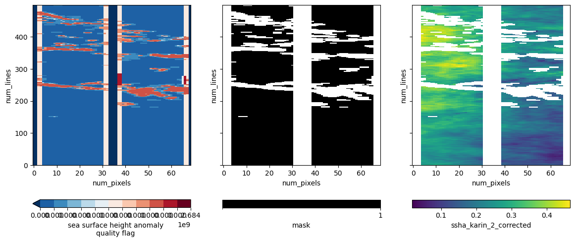
We’ve applied the quality mask to the ssha_karin_2 variable and visualized the result!